

Bukit Besi Peak Introduce
For residents of Selangor, the pursuit of invigorating outdoor activities and a breath of fresh air often leads to exploring the verdant hills and trails that dot our landscape. Among these, Bukit Besi Peak stands out as a truly unique and rewarding hiking destination. Nestled conveniently near the border of Kuala Lumpur and Selangor, this 'Iron Hill' offers a surprisingly diverse and engaging experience, perfect for those looking to challenge themselves while being rewarded with truly spectacular vistas of our vibrant capital city. It’s more than just a hike; it’s an adventure that combines physical exertion with the serenity of nature and breathtaking panoramic views.
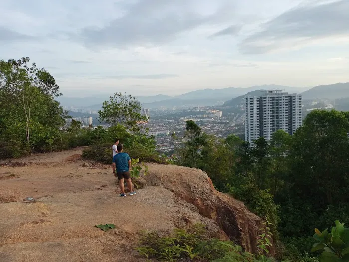
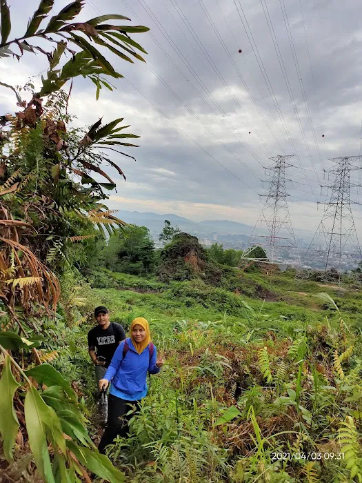
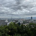
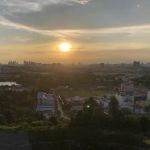
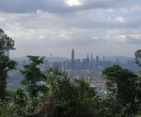
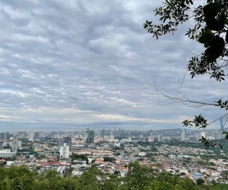
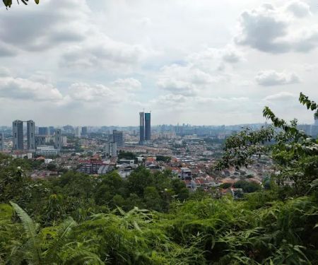
Bukit Besi Peak has garnered a reputation for its blend of accessibility and exciting challenges. While some might consider it a "beginner" hike, as one local review rightly points out, it can certainly feel like a "medium level" endeavor, especially for those venturing onto its more diverse paths. This hill promises an evolving landscape, from relatively straightforward sections to areas where "you need to climb (there’s rope to assist)," adding an element of thrill to your ascent. The promise of witnessing "all the 4 towers in Msia" (referring to KL's prominent skyscrapers) mid-way through your climb is a significant draw, motivating hikers to push a little further.
In this comprehensive article, we'll delve into everything that makes Bukit Besi Peak a fantastic choice for locals in Selangor. We'll explore its precise location and how easily accessible it is from various parts of the state. We'll detail the various types of terrains and experiences it offers, highlight its unique features that make it a memorable climb, and provide essential tips for a safe and enjoyable journey. While promotions in the traditional sense don't apply to a natural hiking area, we'll cover key visitor information and conclude with a clear explanation of why Bukit Besi Peak is ideally suited for the active and nature-loving residents of Selangor, offering a consistently satisfying outdoor escape.
Bukit Besi Peak is strategically located at the fringes of Kuala Lumpur and Selangor, making it a highly accessible hiking spot for residents across both regions, particularly those in the Cheras and Alam Damai areas. While its address is broadly listed as 56000 Kuala Lumpur, Selangor, Malaysia, the main trailhead and popular starting point is often associated with the Alam Damai area in Cheras, Federal Territory of Kuala Lumpur, which borders Selangor.
The most common starting point for Bukit Besi is near Altitude 236 Condominium or opposite OCBC Bank in Alam Damai, Cheras. For those driving, there is typically parking available around these shop lots or at a larger parking area behind them. The initial part of the trail often involves a paved road that leads steeply up towards water reservoirs.
For individuals relying on public transportation from various parts of Selangor, reaching Bukit Besi might involve a combination of LRT/MRT and ride-hailing services. The nearest MRT station would likely be Taman Connaught or Cheras Sentral on the Kajang Line. From these stations, a short ride via Grab or a local taxi would be the most convenient way to reach the trailhead in Alam Damai. While direct bus routes might require transfers or a longer walk, ride-hailing services offer a direct and efficient way to get to the starting point. The well-known nature of Cheras and Alam Damai among local drivers ensures relatively straightforward navigation to Bukit Besi, making it a feasible half-day or full-day outing for nature enthusiasts in Selangor.
Bukit Besi Peak, as a natural hiking area, primarily offers opportunities for outdoor recreation and exploration, rather than traditional "services" in a commercial sense. However, it implicitly provides several key features that benefit hikers:
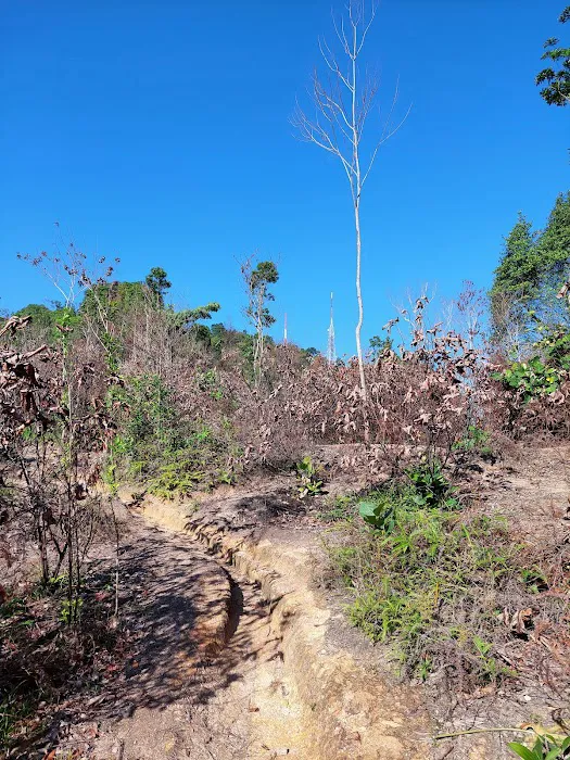
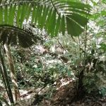
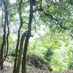
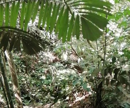
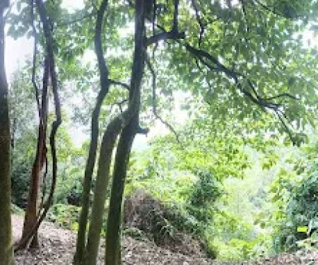
- Well-Defined Trails: While there might be multiple paths, there are generally well-trodden trails that guide hikers towards the peak and other attractions like the waterfall. Some paths are hard soil, while others might involve rocky terrain.
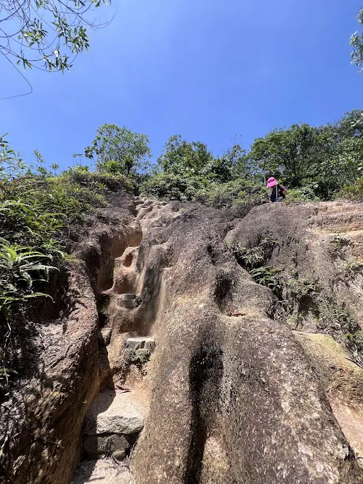
- Rope Assistance for Climbs: For more challenging, ascending sections, the presence of ropes (as mentioned in reviews) provides crucial assistance, making certain climbs manageable and adding an element of adventure.
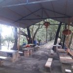
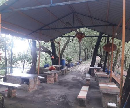
- Resting Stops: Along the trail, there are typically designated or natural "resting stop" where hikers can take a breather, rehydrate, and enjoy the surroundings before continuing their ascent.
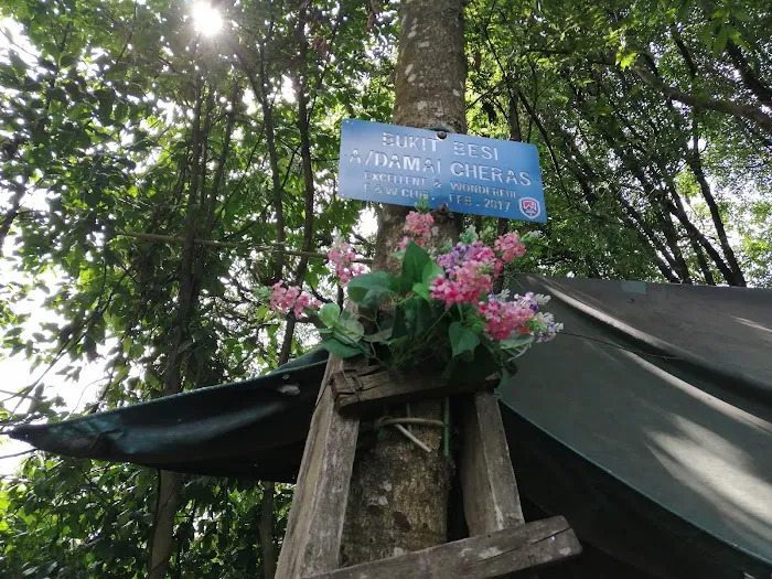
- Signage (Informal): While not always official, informal markers or chalked directions, as sometimes noted by hikers, can assist in navigating the various routes and junctions within the trail network.
- Natural Environment for Exercise: The primary service is providing a natural environment for physical activity, offering a challenging workout for various fitness levels, from moderate to those seeking a longer trek.
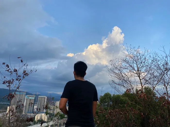
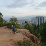
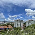
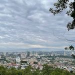
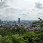
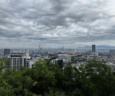
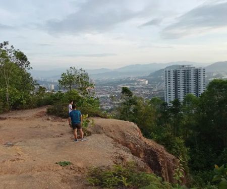
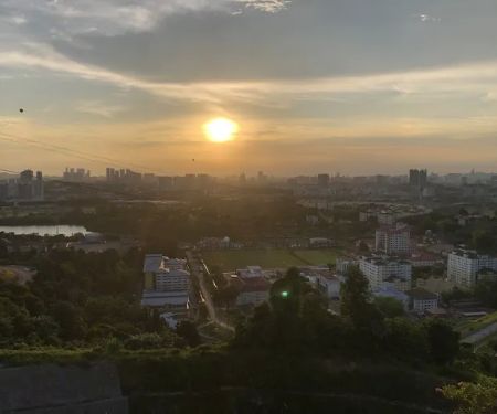
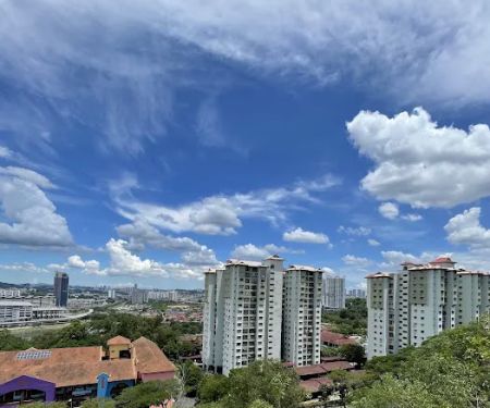
- Scenic Viewpoints: The trail offers multiple viewpoints that reward hikers with "beautiful KL skyline" views, including the iconic towers, making the effort worthwhile for photography and appreciation of the urban landscape.
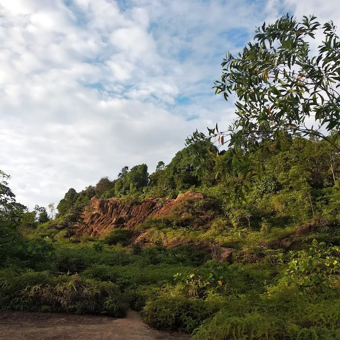
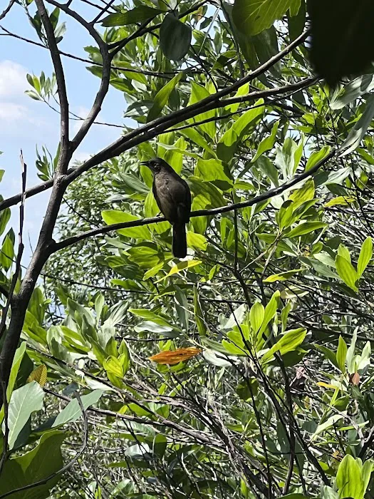
- Access to Nature: It provides an escape from urban life, allowing visitors to immerse themselves in lush greenery, fresh air, and encounter local flora and fauna (e.g., monkeys near the communication tower).
Bukit Besi Peak boasts several unique features and highlights that make it a compelling destination for hikers in Selangor:
- Panoramic KL Skyline Views: This is arguably the biggest draw. The trail offers strategic viewpoints where hikers are "rewarded with beautiful KL skyline," allowing you to "see all the 4 towers in Msia." This iconic view is a major highlight and a fantastic photo opportunity.
- Varying Trail Difficulty with Assisted Climbs: Unlike some hills that are purely walks, Bukit Besi offers a mix of "ascending" paths and sections where "you need to climb (there’s rope to assist)." This adds an exciting challenge, making it suitable for those looking for more than just an easy stroll.
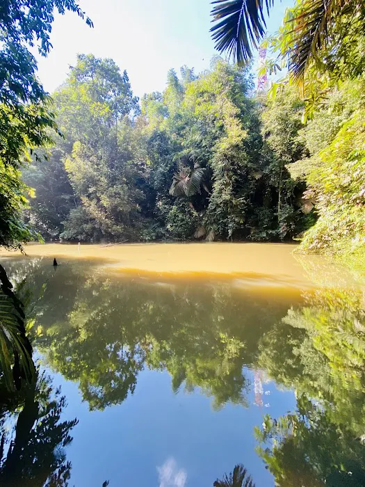
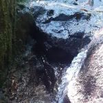
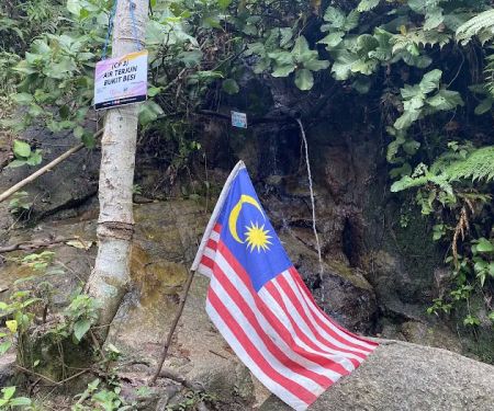
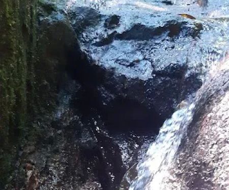
- Mini Waterfall & Jungle Gym: The presence of a "small waterfall" (which can be a detour) and a "jungle gym" (if you can find it!) adds extra points of interest, offering opportunities for exploration and diverse activities beyond just reaching the peak.
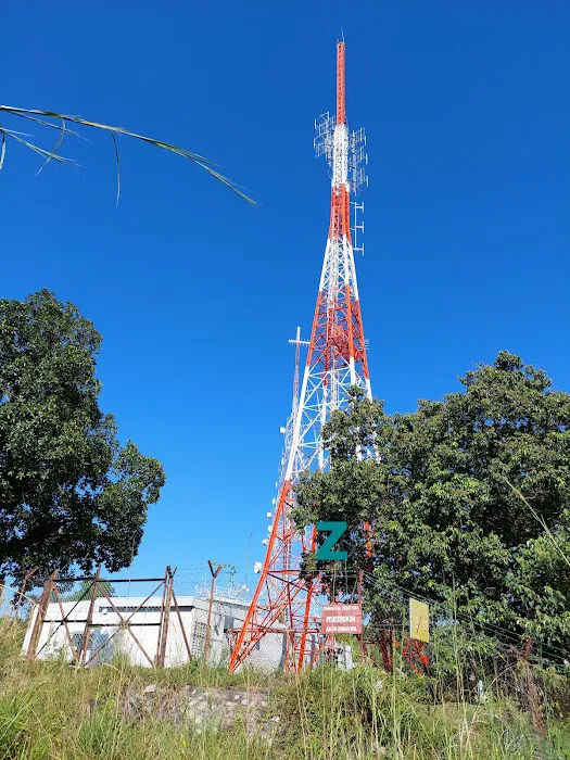
- Telecommunications Towers at the Peak: Reaching the summit, marked by "telecommunications towers," provides a clear sense of accomplishment and often offers another vantage point for views.
- Option for Different Routes: As highlighted by a reviewer, there are possibilities to "use diff road" on the descent, allowing for varied experiences on repeat visits and catering to different fitness levels or desires for exploration.
- Quiet and Less Crowded Trails: Compared to some more popular hiking spots, Bukit Besi can be "very less people if you're looking for some quiet trailing," offering a more serene experience for nature lovers.
- Opportunities for Wildlife Sightings: Encounters with local wildlife, such as "monkeys near the communication tower," add to the natural appeal of the hike.
As Bukit Besi Peak is a natural hiking area managed by local authorities or forest departments, it does not typically offer "promotions or special offers" in the commercial sense that a business would. Its value lies in the natural experience it provides. However, locals can still benefit from certain 'advantages' or considerations that might resemble promotions:
- Free Access: Generally, access to hiking trails like Bukit Besi is free of charge, which is a significant "promotion" in itself, making it an accessible and budget-friendly recreational activity for everyone in Selangor.
- Community-Led Events: While not organized by the 'venue' itself, local hiking groups or communities often organize group hikes to Bukit Besi. Joining such groups can offer benefits like shared transport, guidance from experienced hikers, and a social aspect, effectively making the hike more accessible or enjoyable.
- Self-Guided Exploration: The flexibility to explore the various trails at your own pace and choose your level of challenge (e.g., short routes to the communication tower or longer loops to the waterfall) is a form of "customized experience" that caters to individual preferences.
- Nature's "Seasonal" Offers: The trail's condition changes with weather, offering different experiences. For example, avoiding it after heavy rain for safety reasons, or enjoying it on a cool, clear morning for best views, could be seen as optimizing your visit based on natural "promotions."
Visitors should always prioritize safety by checking weather conditions before heading out, wearing appropriate attire, and bringing sufficient water. Information about any temporary trail closures or new regulations would typically be communicated via local community groups, social media, or signage at the trailhead.
As Bukit Besi Peak is a natural landmark and not a commercial establishment, there isn't a dedicated customer service phone number or official website in the traditional sense. However, essential location information is available for navigation:
- Address: 56000 Kuala Lumpur, Selangor, Malaysia (Note: The specific trailhead is often associated with Alam Damai, Cheras. GPS coordinates for the starting point near OCBC Bank Cheras, Alam Damai are approximately 3.075513, 101.736365)
For planning your hike, it is best to rely on:
- GPS Navigation: Use mapping applications (Google Maps, Waze) and input "Bukit Besi Trailhead Alam Damai" or the provided GPS coordinates for precise directions to the starting point.
- Online Hiking Forums/Groups: Local hiking communities on platforms like Facebook or WhatsApp are excellent resources for the most up-to-date information on trail conditions, recent closures (if any, like the reported closure after the telecommunication tower), and advice from experienced hikers. These groups are often the best "contact point" for real-time information and tips.
- Local Advice: As highlighted in reviews, sometimes the best contact is a friendly "hiker coming down" who can offer quick, on-the-spot advice about the trail.
Since there are no official "operating hours" for a natural hill, visitors can typically access the trails from dawn to dusk. However, for safety reasons, it is highly recommended to start early in the morning to avoid the midday sun and ensure you complete your hike before dark, especially given the challenging sections and open paths.
In conclusion, Bukit Besi Peak is an exceptionally suitable and rewarding hiking destination for locals in Selangor, offering a perfect blend of natural beauty, physical challenge, and stunning urban vistas. Its location, easily accessible from various parts of Selangor and Kuala Lumpur via ride-hailing services or a combination of public transport and short rides, makes it a convenient choice for a day out in nature without venturing too far from the city's comforts.
What truly makes Bukit Besi resonate with the local hiking community is its diverse terrain and the sense of accomplishment it provides. From the initial ascending paths to sections requiring rope assistance, the trail offers a satisfying challenge that caters to different fitness levels. The rewarding views of the Kuala Lumpur skyline, where you can "see all the 4 towers in Msia," serve as magnificent motivation and a fantastic backdrop for those well-deserved photos. The existence of different routes, a potential "mini waterfall," and even a "jungle gym" ensures that every visit can offer a new discovery, keeping the experience fresh and engaging.
For Selangor residents seeking an active escape into nature, a chance to clear their minds, and an opportunity to witness breathtaking cityscapes, Bukit Besi Peak is a compelling option. It offers a free, accessible, and consistently enjoyable outdoor adventure that strengthens both body and spirit. Whether you're a seasoned hiker or looking to step up from beginner trails, Bukit Besi provides a truly fulfilling experience that makes the effort entirely worthwhile.
Bukit Besi Peak Photos
Bukit Besi Peak Location
Bukit Besi Peak
56000 Kuala Lumpur, Selangor, Malaysia
 Bukit Besi Peak
56000 Kuala Lumpur
 Air Terjun @Bukit Besi
5
 Bukit Besi Stream
77
 Bukit Besi viewpoint
Bukit Mandarina
 Jeram Besar Bukit Besi
79
 Bukit Besi Trailhead
1
 Puncak Gemilang
43200 Kuala Lumpur
 Desa Petaling, Kuala Lumpur u9752u9f8du5c71
Jalan 5/125
 Oh My Maya's Peak
3QW2+XV
 Lookout Shelf
3QW2+XV Oh My Maya Peak
 Lavvyy's Hill
21
 Ketumbar Hill Top Camp
56100 Hulu Langat
 Ketumbar Hill
Jalan Ketumbar
Bukit Besi Peak Reviews
It was definitely a pleasent experience and surprised too. The starting point or trail head was easy to locate.. (was my first time) and it so happen I met a hiker coming down.. therefore some quick questions where what when how was so helpful.. (thank you uncle).The journey up was ascending, do bring along hiking shoes and stick..the path was just hard soil, bushes around.. my advise wear long pants.. there’s a few locations you need to climb (there’s rope to assist) .. and mid way.. you are rewarded with beautiful KL skyline.. you see all the 4 towers in Msia..Heading up further, you come across two resting stop.. which is nice if you really need to take a breather… pushing further… you seek the peak.. the telecommunications towers..Didn’t get a chance to detour to the small waterfall.. perhaps the next hike.Overall.. am satisfied, took me 2 hrs but I believe it shld be shorter (if you a fast hiker) .. my advise.. take it slow, savor the views and enjoy the breeze.. do wear a hat.. some paths are open and the ☀️ is hot too. Having said that.. if it rained the prev nite.. I would avoid this trail.Happy Hiking..
May 17, 2025 · WS HWhy all hikers said that this hill is for beginner. This is like medium level for me. I'm quite surprised by all those comments. It has jungle gym if you can find it. It took me 4 hours to hike all the way from start and then go to the peak, then go down, but different road and i found small waterfall, and go up, but be careful, cuz many hikers they use back the road they walk before coming to the fountain. I'm trying to use another road. So I use diff road, it's so long, i wonder when it will finish. Haha some hikers just do half way. It depends on your fitness. BTW this hills got large rock, so you need to use rope. Then. Don't have to bring stick. It's difficult for you to climb those rocks.Update! : they close the trail after the pencawang. So the trail not so long, you can finish around 30 mins.
Dec 10, 2020 · EmmaNever despise any hill. Bukit Besi maybe a small hill and not widely explored, but the longer trail takes you up first and then all the way down before turning up again after the river. The second part of the ascend can be strenuous. Thanks to the kind folks who put up ropes at the steep sections and setting up the rest tents. A good workout. Good to come in group if you are not familiar as the trails are junglish. The peak is marked by the Telekom transmission tower. Beautiful nature and breathtaking views on the way pays off the tiredness.This hill hold many surprises. If you start somewhere to the left side of the trailhead following a clear small path, you will come to a tunnel-like hole after which there will be quite a verticle climb. Good to challenge your arm strength at this stretch.There is a pond somewhere close to the peak. Descend from the open space for about 50m. Beautiful reflections. Looking forward to new adventures here
Aug 08, 2020 · Low Lee LingFairly easy hike in the beginning but gets more challenging after. It's not a tall hill but definitely a bit steep and slippery. Nevertheless lots of local folks and elderly climb it like a spiderman. They even carry all sorts of food and cooking utensils to the rest station... They put young people like me to shame hahahaPlenty of bugs and mosquitoes here. Do use insect repellent or wear long sleeves. Gloves can be useful too.
Aug 26, 2022 · user0341yoqGood hike, went on a tougher trail today. Many climb.
Nov 07, 2020 · Marcus Leong
More Adventure
 Air Terjun @Bukit Besi4.0 (17 reviews)
5, Jalan 38/142, Taman Orkid Desa, 56000 Kuala Lumpur, Wilayah Persekutuan Kuala Lumpur, Malaysia
 Bukit Besi Stream4.0 (3 reviews)
77, Jalan 38/142, Taman Orkid Desa, 56000 Kuala Lumpur, Wilayah Persekutuan Kuala Lumpur, Malaysia
 Bukit Besi viewpoint4.0 (7 reviews)
Bukit Mandarina, 56000 Kuala Lumpur, Wilayah Persekutuan Kuala Lumpur, Malaysia
 Jeram Besar Bukit Besi4.0 (2 reviews)
79, Jalan 38/142, Taman Orkid Desa, 56000 Kuala Lumpur, Wilayah Persekutuan Kuala Lumpur, Malaysia
 Bukit Besi Trailhead4.0 (327 reviews)
1, Jalan Alam Damai, Alam Damai, 56000 Cheras, Wilayah Persekutuan Kuala Lumpur, Malaysia
 Puncak Gemilang5.0 (5 reviews)
43200 Kuala Lumpur, Selangor, Malaysia
 Desa Petaling, Kuala Lumpur u9752u9f8du5c714.0 (25 reviews)
Jalan 5/125, Desa Petaling, 57100 Kuala Lumpur, Wilayah Persekutuan Kuala Lumpur, Malaysia
 Oh My Maya's Peak4.0 (16 reviews)
3QW2+XV, 56100 Kuala Lumpur, Federal Territory of Kuala Lumpur, Malaysia
 Lookout Shelf5.0 (1 reviews)
3QW2+XV Oh My Maya Peak, 56100 Kuala Lumpur, Wilayah Persekutuan Kuala Lumpur, Malaysia
 Lavvyy's Hill1.0 (1 reviews)
21, Jalan Kesuma, Taman Bukit Belimbing, 43300 Balakong, Selangor, Malaysia
 Ketumbar Hill Top Camp4.0 (308 reviews)
56100 Hulu Langat, Selangor, Malaysia
 Ketumbar Hill4.0 (1447 reviews)
Jalan Ketumbar, Taman Cheras, 56100 Kuala Lumpur, Wilayah Persekutuan Kuala Lumpur, Malaysia
Categories
Popular
 Double Homes TPG4.0 (6 reviews)
 BOZZ BABY JOHN (ROTI JOHN)5.0 (5 reviews)
 Jaybee Deer Chalet4.0 (2 reviews)
 JB Homestay4.0 (4 reviews)
 VV Space Kota Kemuning3.0 (8 reviews)
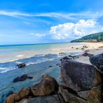 Teluk Cempedak4.0 (1093 reviews)
Must-Read Blog Posts
Most Searched
Trending Blog Posts
 Exploring the Architectural Beauty of Mosques in Malaysia: A Journey Through Islamic Architecture
 Exploring the Unique Designs of Mosques in Malaysia: A Journey Through Islamic Architecture
 How to Get to the Famous Mosques in Kuala Lumpur by Public Transport: A Complete Travel Guide
 Visiting Malaysia’s Most Famous Mosques During Eid: A Unique Cultural Experience
 Top Mosques to Visit During Ramadan in Malaysia: A Traveler's Guide
 Discover the History of Masjid Titiwangsa in Kuala Lumpur: A Cultural and Architectural Gem