
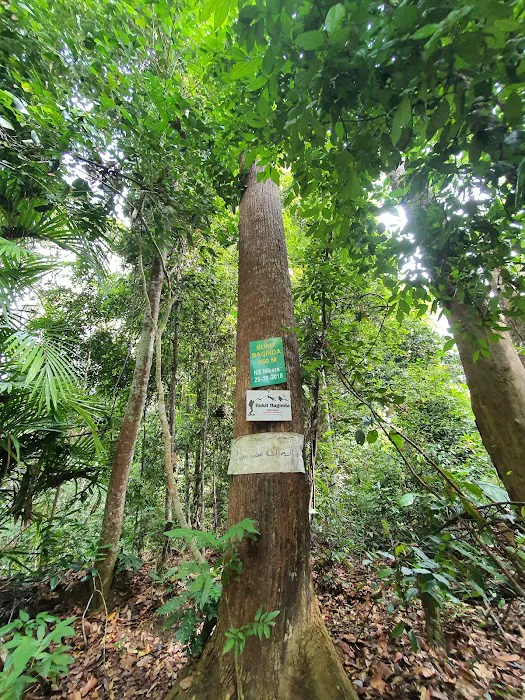
Bukit Baginda Trailhead Introduce
Are you a Negeri Sembilan local with an adventurous spirit, constantly seeking new heights and breathtaking views? Then it's time to lace up your hiking boots and discover the captivating Bukit Baginda Trailhead! Nestled in the tranquil landscapes of Kampung Majau, Batu Kikir, this increasingly popular hiking spot offers more than just a workout; it promises an unforgettable journey through lush greenery, unique geological formations, and panoramic vistas that will leave you in awe. It's quickly becoming a beloved destination for those who appreciate a challenging yet rewarding outdoor experience right here in our beautiful state.
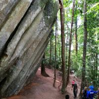
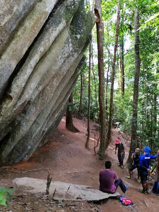
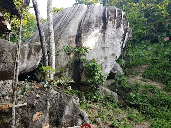
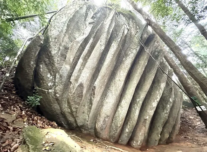
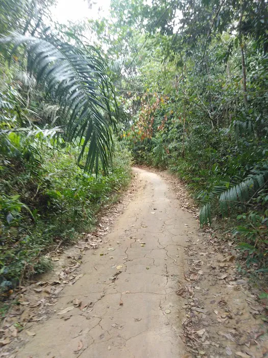
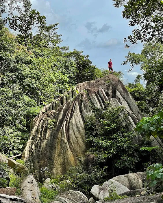
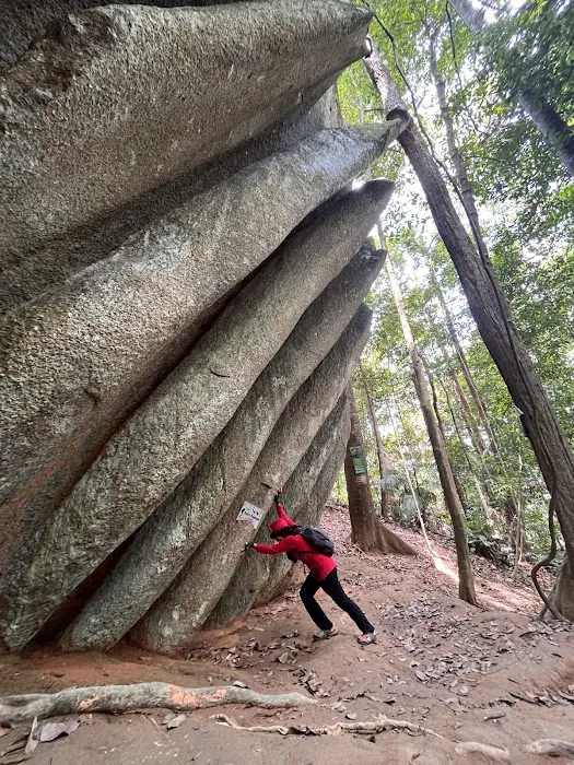
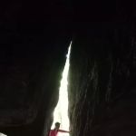
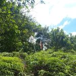
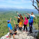
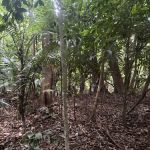
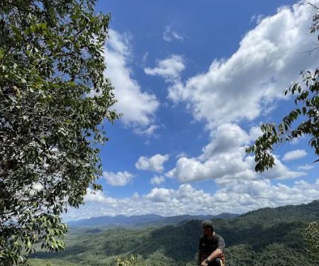
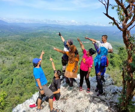
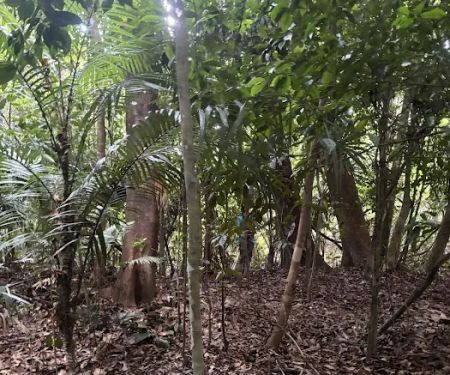
Bukit Baginda is renowned for its distinctive natural features, particularly the iconic "Wave Rock" near its summit, which has captivated hikers and photographers alike. This striking rock formation, resembling a gigantic ocean wave, is a testament to the incredible natural artistry found within our very own Negeri Sembilan. But the allure of Bukit Baginda extends beyond this famous landmark. The trail itself is an adventure, winding through rubber plantations, secondary forests, and past massive boulders that inspire wonder and provide excellent photo opportunities.
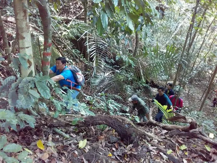
While the trail is considered moderately challenging with steep sections and requiring ropes for assistance in some parts, it's this very challenge that makes the summit so rewarding. The sense of accomplishment upon reaching the peak, coupled with the magnificent views, is unparalleled. As one local hiker enthused, "Cool place to go!" and others highlighted the "all up, steep most time, rope is there to assist" nature of the climb. This transparency about the trail's difficulty ensures that hikers arrive prepared for an exhilarating experience.
Moreover, the community surrounding Bukit Baginda adds to its unique charm. There's a friendly atmosphere, with local caretakers who genuinely want you to have a good experience. The opportunity to discover hidden gems like the "secret cave for good photography opportunity" (with a friendly tip to the caretakers, of course!) adds an element of mystery and discovery that truly sets Bukit Baginda apart from other hiking trails. This personal touch and the chance to interact with locals who know the terrain best enrich the entire hiking adventure.
For Negeri Sembilan residents, Bukit Baginda Trailhead offers a perfect blend of physical challenge, natural beauty, and local charm. It’s an ideal spot to push your limits, capture stunning photographs, and create lasting memories with friends and family, all while exploring the hidden wonders of our home state.
Location and Accessibility
The Bukit Baginda Trailhead is conveniently situated in Kampung Majau, 72200 Batu Kikir, Negeri Sembilan, Malaysia. This location makes it a highly accessible hiking destination for residents across Negeri Sembilan and even those from neighbouring states. Batu Kikir is a rural town, providing a peaceful backdrop for your outdoor adventure, yet it's well-connected enough to major roads for ease of travel.
If you are travelling from Seremban, the state capital, Bukit Baginda is approximately a 45-minute drive, generally via Federal Route 51 or Jalan Kuala Pilah. The journey is scenic, passing through charming Negeri Sembilan kampungs and oil palm plantations. For those coming from Kuala Lumpur, the drive typically takes around 1.5 to 2 hours, making it a feasible option for a day trip or a weekend getaway. The trailhead in Kampung Majau is generally well-known among locals, and navigation apps can easily guide you to the specific starting point.
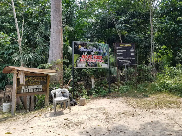
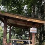
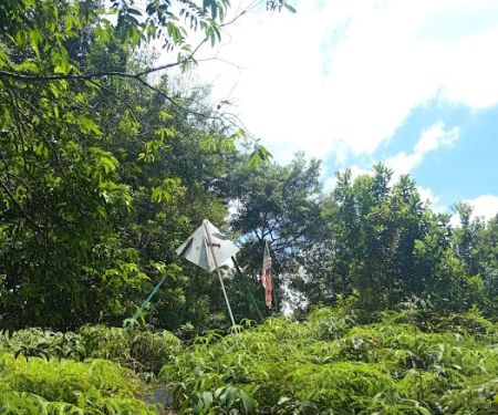
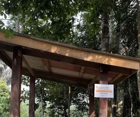
Upon arrival, you'll find that parking is available, as confirmed by visitor reviews, which is a significant convenience for hikers. The trailhead is often managed by local villagers or community members who assist with parking and guidance, further enhancing the accessibility and welcoming nature of the place. While the immediate area around the trailhead is relatively undeveloped to maintain its natural charm, the presence of basic facilities and helpful locals ensures a smooth start to your hiking experience. Its proximity to Batu Kikir town also means that amenities like petrol stations or small eateries are within reasonable reach should you need them before or after your hike.
Services Offered
- Parking Facilities: Designated areas for vehicles at the trailhead, ensuring convenience for visitors.
- Toilet Facilities: Basic toilet facilities are available at the trailhead, as noted by visitor reviews, which is crucial for a comfortable hiking experience.
- Local Guides/Caretakers: Villagers often act as informal guides or caretakers, providing assistance, local insights, and sometimes showing "secret" spots (tipping recommended).
- Trail Maintenance: The routes are generally maintained by local community efforts, including ropes to assist on steeper sections, as confirmed by hikers.
- Visitor Information (informal): Local caretakers can often provide up-to-date information on trail conditions or specific points of interest.
Features / Highlights
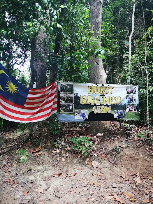
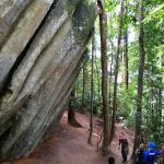
- Iconic Wave Rock: The most prominent feature, a stunning natural rock formation resembling a massive ocean wave, offering incredible photographic opportunities at the summit.
- Challenging & Rewarding Trails: The hike includes steep ascents and sections with ropes for assistance, providing a good physical challenge for hikers of moderate fitness levels.
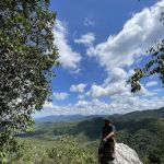
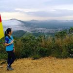
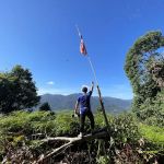
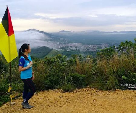
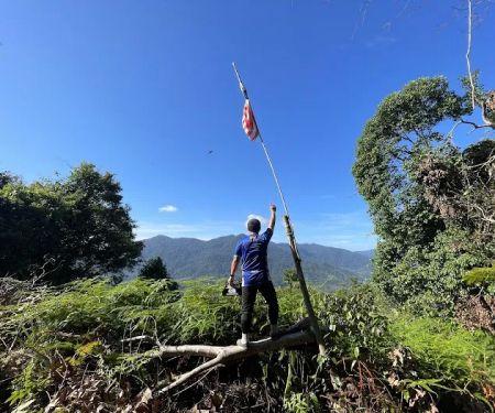
- Panoramic Summit Views: From the peak, hikers are rewarded with breathtaking panoramic vistas of the surrounding Negeri Sembilan landscape.
- Unique Geological Formations: Beyond the Wave Rock, the trail features numerous large and uniquely shaped boulders, adding to the scenic appeal and geological interest.
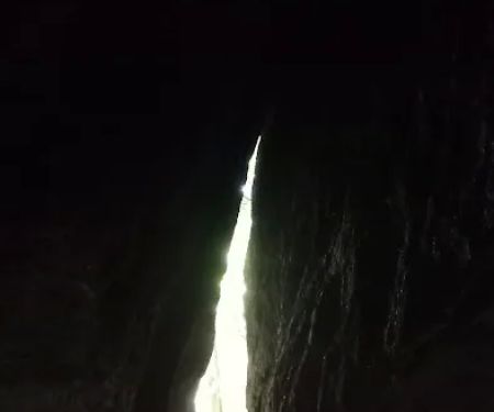
- "Secret Cave": As highlighted by local reviews, there is a "secret cave" or rock shelter area, often shown by local caretakers, offering unique photography spots and a touch of mystery.
- Diverse Flora and Fauna: The trail passes through rubber plantations and secondary forest, providing opportunities to observe local plant life and listen to the sounds of nature.
- Community Engagement: The presence of friendly local caretakers enhances the overall experience, offering a personal touch and valuable local knowledge.
- Proximity to Other Attractions: Being in Batu Kikir, it's also relatively close to other local attractions in Negeri Sembilan, allowing for a broader exploration of the state.
Promotions or Special Offers
As Bukit Baginda Trailhead operates more as a natural hiking area with local community involvement rather than a commercial attraction, formal "promotions" or "special offers" in the traditional sense are not publicly advertised. However, visitors should be aware of certain local arrangements and potential costs:
- Entrance/Maintenance Fee: Based on public information and hiker reviews, there is typically a small fee collected by local caretakers or the Village Community Development Council (MPKK). This fee generally covers aspects like parking, trail maintenance, and possibly a forest permit. Previous reports indicate a total fee of around RM16 (RM5 for forest permit, RM6 entrance, RM5 parking), though this can vary and should be confirmed upon arrival. It's always good to have small denominations of Malaysian Ringgit ready.
- Tipping Local Caretakers: As noted in reviews, being "nice to the abang who takes care of the route" and tipping them can lead to unique experiences, such as being shown the "secret cave for good photography opportunity." This is an informal but highly recommended practice to appreciate their efforts.
- Group Rates: While not explicitly stated, for larger hiking groups or organized outings, it might be possible to inquire about any specific arrangements or reduced rates by contacting the local community leaders or the Negeri Sembilan Forestry Department (for forest permits). Refer to the contact section for general forestry department contacts for the region, although direct contact for Bukit Baginda specifically may vary.
It’s important to approach Bukit Baginda with the understanding that it’s a natural resource maintained with local community support, rather than a commercially driven tourist spot. The "offers" here come in the form of a unique, authentic hiking experience and the chance to interact with the local community.
Contact Information
Address: Kampung Majau, 72200 Batu Kikir, Negeri Sembilan, Malaysia
For the most current information regarding access, fees, or any specific requirements for hiking at Bukit Baginda Trailhead, direct formal contact might be through the relevant local authorities or forestry department, as the trailhead itself doesn't have a dedicated public contact number. However, based on available information:
- General inquiries for advanced permit applications in the Northern Negeri Sembilan (Jelebu) areas, which may include routes that intersect with such reserves, can sometimes be directed to the forestry officer, Puan Shima, via WhatsApp at +6012 942 5094. It's advisable to specify Bukit Baginda in your inquiry.
- Upon arrival at the trailhead, local caretakers or community members are often present to assist with fees and provide immediate guidance.
- For general information about hiking in Negeri Sembilan forest reserves, you may also consider contacting the Negeri Sembilan State Forestry Department. Their general contact details can typically be found on the Jabatan Perhutanan Semenanjung Malaysia (JPSM) website.
It is highly recommended to check recent reviews or local hiking forums for the most up-to-date informal contacts or direct advice from other hikers who have recently visited.
Conclusion: Why This Place is Suitable for Locals
For the adventurous residents of Negeri Sembilan, Bukit Baginda Trailhead is more than just a hiking spot; it’s an accessible and deeply rewarding natural escape that perfectly aligns with the local appreciation for outdoor activity and authentic experiences. Its unique blend of physical challenge and natural beauty makes it an ideal destination right on our doorstep.
Firstly, the ease of access from various parts of Negeri Sembilan, including Seremban, makes it a convenient choice for a day trip. There’s no need for extensive travel plans or complicated logistics; just a relatively short drive to immerse yourself in nature. This accessibility is a significant advantage for locals seeking a quick yet impactful break from their daily routines.
Secondly, Bukit Baginda offers a diverse and engaging hiking experience. From navigating steep ascents with the aid of ropes to discovering intriguing rock formations like the famous Wave Rock, every step of the trail provides something new and exciting. This variety ensures that both seasoned hikers and those looking for a moderate challenge will find it deeply satisfying. The opportunity to uncover "secret caves" with the help of friendly local caretakers adds an element of discovery and personal connection that enriches the entire journey, fostering a sense of adventure and local pride.
Finally, supporting Bukit Baginda also means contributing to the local community that helps maintain the trails and ensures its continued preservation. The presence of local "abang" who assist hikers and provide insights creates a welcoming and safe environment, embodying the true spirit of Negeri Sembilan hospitality. It's a place where you can challenge yourself, revel in stunning natural vistas, and connect with the heart of our state's beautiful landscapes. Bukit Baginda Trailhead truly is a local gem, inviting every Negeri Sembilan resident to explore its majestic trails and discover the wonders that lie within our own backyard.
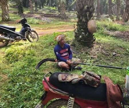
Bukit Baginda Trailhead Photos
Bukit Baginda Trailhead Location
Bukit Baginda Trailhead
Kampung Majau, 72200 Batu Kikir, Negeri Sembilan, Malaysia
 Bukit Baginda Trailhead
Kampung Majau
 Bukit Baginda New Trail (Gochang)
V6JM+QC
 Bukit Bunga, Kg. Datok Johan
Kampung Baharu Serting
 Bukit Batu Sawa Parking/Trailhead
Unnamed Road
 Bukit Batu Sawa
X4HP+HM
 Bukit Batu Sawa Hilltop
Peradong
 Bukit Penarikan
Kampung Kuala Sialang
 Puruh top point
Kampung Puruh
 Bukit Bertam Kg Gamin
Unnamed Road
 Abas family venture perladangan
27CH+7Q
 Bukit Segambut
P4FM+8P
 Bukit Tajali
71600 Kuala Klawang
 Start Point Bukit Senaling Hiking Trail
Unnamed Road
Bukit Baginda Trailhead Reviews
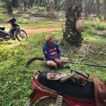
Cool place to go! Make sure you tip the abang who takes care of the route nicely. Be nice to him and he will show you the secret cave for good photography opportunity.
Apr 11, 2024 · Zhi Xiong ChongWent weekday. Parking is available n toilet is there. There are 2 person come in motorcycle claim to be the owner of cp1 cp2. He will wait at the big rock area cp2. He ask for some fee. To save trouble we pay him. He guide us to cave under the rock n help to take some pictures. They only stay at cp2. We hike ourselves towards cp3 to cp8 peak. It's all up, steep most time, rope is there to assist. Once reach peak, turn left to wave rock. Whole hiking took 4 hours as we are slow and enjoying rocks.
Mar 01, 2024 · John ChengI have always wanted to go to Bukit Baginda but have been procrastinating it for years and finally made it there today.There are altogether 8 check points, quite taxing for me who doesn’t exercise nor hike on regular basis.Lacking of signage’s so it’s advisable to go in groups with someone who knows the direction otherwise you will easily get lost.Need not park your car at the carpark, there are roadside parkings where you can park so long you don’t park at people’s front gate nor block traffic.Better bring mosquito repellant as we did encounter some mosquitoes and remember to bring at least 1.5 litres to 2 litres of water to stay hydrated.You met want to bring a rain coat just in case it rains, I didn’t prepare and thus got myself drenched in the rain.
May 22, 2024 · Carol YeeMet one of the nicest & friendly gatekeeper of this place, a hiking trip turned into an explorative day for all of us. (Maybe we were the only group who came early) He took the time bringing us around and showed us all the nice cool spots to take pictures!
Apr 09, 2024 · Carina ChongGreat hiking experience! Difficulty is moderate, only 450m but the trail is all the way up. Not much flat surface, when going down hill will feel quite steep. Have to pay more attention during the rainy days, going down will be very slippery. Other than the wave rock, must visit the cave before going up. Btw, there were some monkeys roaming around near the trailhead.
Apr 17, 2022 · Chester Wong
More Adventure
 Bukit Baginda New Trail (Gochang)4.0 (2 reviews)
V6JM+QC, Kampung Gelang, 72200 Batu Kikir, Negeri Sembilan, Malaysia
 Bukit Bunga, Kg. Datok Johan5.0 (3 reviews)
Kampung Baharu Serting, 72300 Simpang Pertang, Negeri Sembilan, Malaysia
 Bukit Batu Sawa Parking/Trailhead4.0 (41 reviews)
Unnamed Road, Kampung Belai, 71600 Kuala Klawang, Negeri Sembilan, Malaysia
 Bukit Batu Sawa0.0 (0 reviews)
X4HP+HM, 71600 Kuala Klawang, Negeri Sembilan, Malaysia
 Bukit Batu Sawa Hilltop4.0 (164 reviews)
Peradong, 71600 Kuala Klawang, Negeri Sembilan, Malaysia
 Bukit Penarikan4.0 (85 reviews)
Kampung Kuala Sialang, 72100 Bahau, Negeri Sembilan, Malaysia
 Puruh top point4.0 (1 reviews)
Kampung Puruh, 71600 Kuala Klawang, Negeri Sembilan, Malaysia
 Bukit Bertam Kg Gamin5.0 (1 reviews)
Unnamed Road, 72000 Kuala Pilah, Negeri Sembilan, Malaysia
 Abas family venture perladangan0.0 (0 reviews)
27CH+7Q, Felda Pasoh Satu, 72300 Simpang Pertang, Negeri Sembilan, Malaysia
 Bukit Segambut0.0 (0 reviews)
P4FM+8P, 71500 Tanjung Ipoh, Negeri Sembilan, Malaysia
 Bukit Tajali4.0 (9 reviews)
71600 Kuala Klawang, Negeri Sembilan, Malaysia
 Start Point Bukit Senaling Hiking Trail4.0 (182 reviews)
Unnamed Road, 72000 Kuala Pilah, Negeri Sembilan, Malaysia
Categories
Popular
 My Gallery @ Al Khatiri Point5.0 (4 reviews)
 HealthLand @ Kota Kemuning4.0 (100 reviews)
 Muzium Sungai Lembing4.0 (1343 reviews)
 Kuantan Palm Court HomeStay4.0 (11 reviews)
 Madrasah Perwira Indah4.0 (11 reviews)
 Setia City Residences4.0 (173 reviews)
Must-Read Blog Posts
Most Searched
Trending Blog Posts
 Exploring the Architectural Beauty of Mosques in Malaysia: A Journey Through Islamic Architecture
 Exploring the Unique Designs of Mosques in Malaysia: A Journey Through Islamic Architecture
 How to Get to the Famous Mosques in Kuala Lumpur by Public Transport: A Complete Travel Guide
 Visiting Malaysia’s Most Famous Mosques During Eid: A Unique Cultural Experience
 Top Mosques to Visit During Ramadan in Malaysia: A Traveler's Guide
 Discover the History of Masjid Titiwangsa in Kuala Lumpur: A Cultural and Architectural Gem