

Bukit Liman Hiking Track Introduce
For those of us in Perak who cherish the outdoors and are always on the lookout for a rewarding physical challenge, the Bukit Liman Hiking Track in Kuala Kangsar offers an excellent opportunity. Nestled along Jalan Baling - Gerik, this popular local spot is more than just a trail; it's a test of stamina, a source of fresh air, and a gateway to stunning views of our beautiful state. It has quickly become a go-to for residents seeking to invigorate their bodies and minds amidst nature, earning a reputation as a great starting point for beginners while still offering a satisfying workout for more experienced hikers.
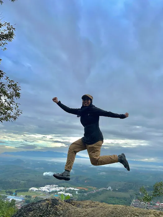
In Perak, we are incredibly fortunate to be surrounded by diverse natural landscapes, from lush rainforests to scenic hills. Bukit Liman Hiking Track perfectly embodies this natural richness, providing an accessible and engaging way to experience our local environment. The exhilaration of reaching the summit after navigating its steep sections, and being rewarded with clean, fresh air and panoramic vistas, is an experience that truly resonates with our love for outdoor adventures. It’s a place where we can escape the daily grind, push our limits, and reconnect with the serene beauty that Perak has to offer.
This article aims to provide a clear, engaging, and factual overview of the Bukit Liman Hiking Track, drawing on the experiences of fellow local users. We will explore its precise location and accessibility, what to expect in terms of the hiking experience, its notable features and highlights, and why it remains a cherished destination for the hiking community in Perak. Whether you’re lacing up your boots for the first time or looking for your next local conquest, Bukit Liman promises a rewarding journey.
---
The Bukit Liman Hiking Track is conveniently located along Jalan Baling - Gerik, specifically in the area of 33020 Kuala Kangsar, Perak, Malaysia. This strategic placement makes it highly accessible for residents of Kuala Kangsar and surrounding districts. For those familiar with the local landmarks, the track is notably situated "in front of MRsm SAs," referring to MRSM Sultan Azlan Shah (Maktab Rendah Sains MARA Sultan Azlan Shah), a well-known educational institution in the area. This makes it easy to pinpoint for anyone driving through or navigating locally.
Jalan Baling - Gerik is a significant road in Perak, connecting various towns and providing a straightforward route to the hiking track. For locals in Kuala Kangsar, reaching the trailhead is typically a short drive, making it an ideal spot for daily exercise or a spontaneous weekend adventure. While specific public transportation directly to the trailhead might be limited for such a natural outdoor spot, the general accessibility of Kuala Kangsar by bus or taxi, followed by a short local ride, would make it reachable for those without private vehicles.
The ease of access, combined with its location amidst a mix of local development and natural landscape, ensures that Bukit Liman remains a popular and convenient choice for the hiking community in this part of Perak. Ample space for parking is usually available along the roadside or in designated areas near the trailhead, catering to the flow of visitors.
---
As a natural hiking track, Bukit Liman offers direct services related to outdoor recreation and physical activity. Unlike commercial establishments, its "services" are inherent in its natural features and the opportunities it provides for hikers. Based on common expectations for hiking trails and local reviews, here’s what you can expect:
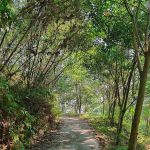
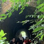
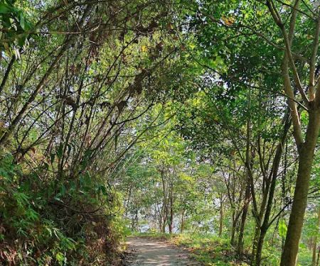
- Defined Hiking Trails: The track provides established paths for hiking. While specific distances or loops aren't detailed, the mention of "2 steep sections to reach the top" indicates a clear route to the summit.
- Uphill Challenge: The primary "service" is the opportunity to test and improve uphill hiking stamina. This makes it an ideal training ground for those looking to build their fitness.
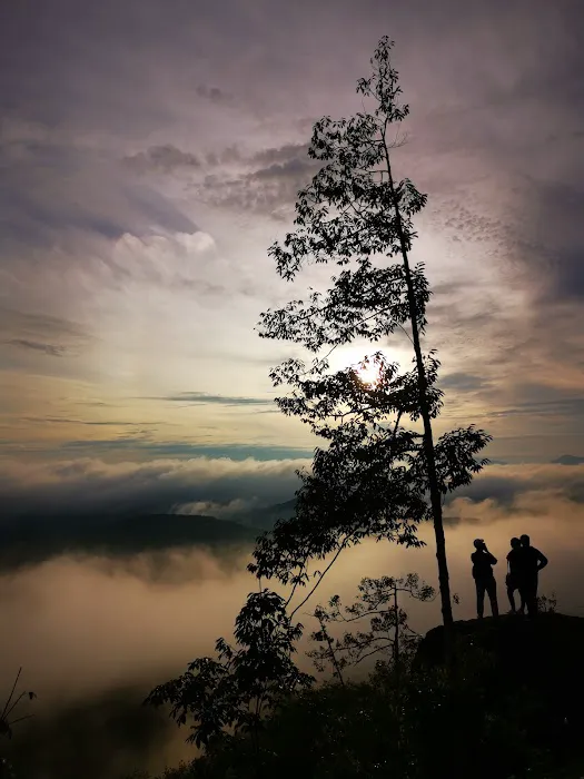
- Access to Fresh and Clean Air: A significant benefit highlighted by users is the availability of "fresh and clean air at the top," providing a refreshing escape from urban pollution.
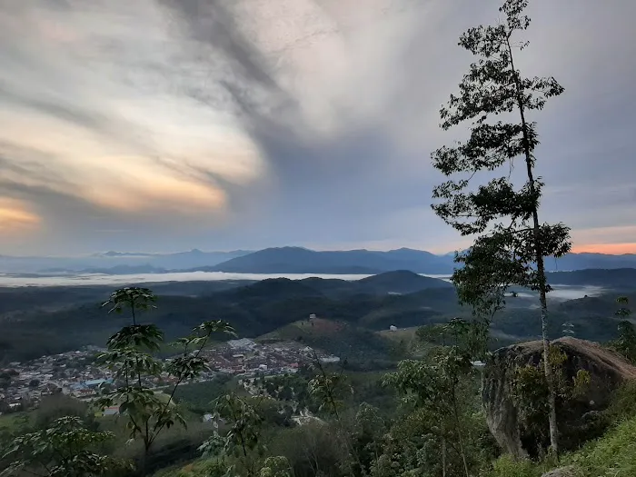
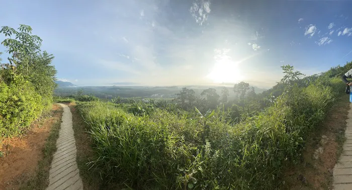
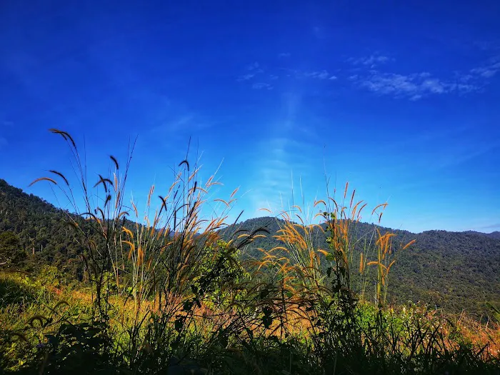
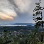
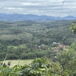
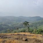
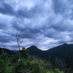
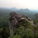
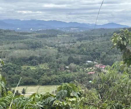
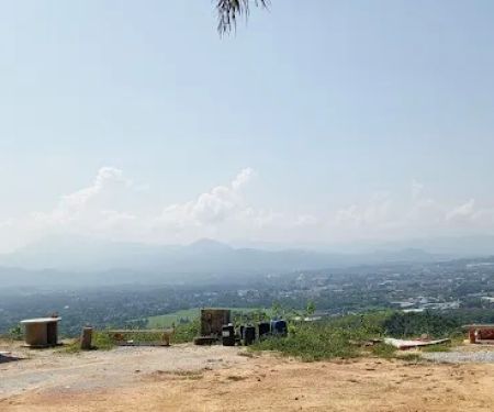
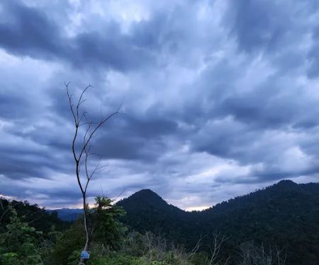
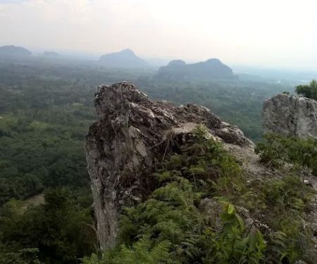
- Scenic Views: The track offers rewarding "view from the top," allowing hikers to enjoy panoramic vistas of the surrounding landscape, which likely includes various orchards as mentioned by a reviewer.
- Natural Environment for Exercise: It provides an unadulterated natural setting for physical exercise, away from paved roads and urban noise.
- Beginner-Friendly Option: Despite the steep sections, the track is considered suitable for beginners, offering a good starting point for those new to hiking, which is a valuable "service" for encouraging participation in outdoor activities.
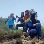
- Opportunity for Solo or Group Hiking: The nature of the track allows for both solitary contemplation during a hike or a social experience when hiking with friends and family.
It is important to note that as a natural outdoor track, formal amenities like restrooms, changing rooms, or dedicated visitor centers are unlikely to be present. Hikers should come prepared with their own water, snacks, and other necessities, and practice Leave No Trace principles, especially regarding waste disposal.
---
Bukit Liman Hiking Track stands out for several key features and highlights that make it a popular choice for locals in Perak, particularly those seeking a challenging yet accessible outdoor experience:
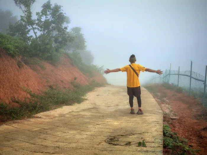
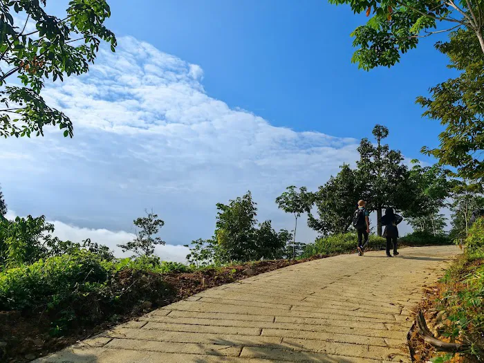
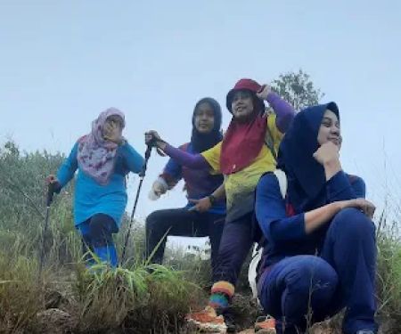
- Excellent Uphill Stamina Test: The most frequently highlighted feature is its effectiveness in testing uphill stamina. With "2 steep sections to reach the top," it provides a genuine physical challenge that appeals to those looking to push their limits and improve their fitness. This makes it a rewarding climb.
- Rewarding Panoramic Views: Upon reaching the summit, hikers are rewarded with a "nice track & of course view from the top." This scenic payoff is a major draw, offering breathtaking vistas of the surrounding Kuala Kangsar landscape, including the mentioned orchards.
- Fresh and Clean Air: A significant highlight, especially in today's urbanized world, is the "fresh and clean air at the top." This provides a rejuvenating experience, allowing hikers to breathe deeply and feel invigorated by nature.
- Beginner-Friendly with a Challenge: Despite the steep sections, the track is recommended for beginners, indicating a manageable yet stimulating experience. This balance makes it accessible to a wider range of fitness levels, encouraging more people to take up hiking.
- Proximity to Local Landmarks: Its location "in front of MRSM SAS" makes it easy to find and provides a familiar reference point for locals. This integration into the local community landscape adds to its appeal.
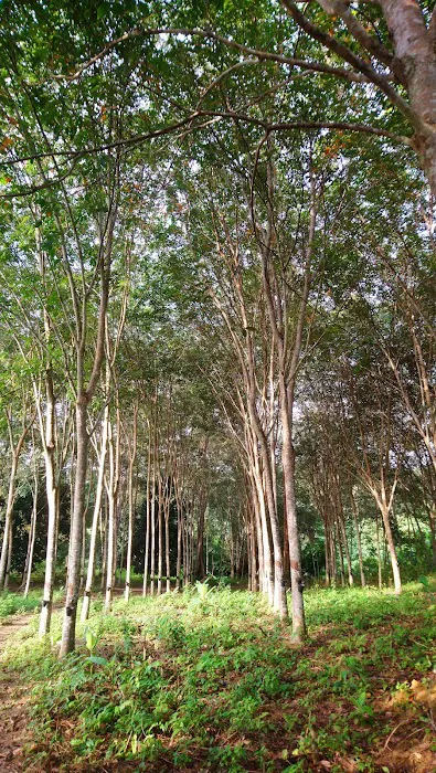
- Experience Local Agriculture: The mention of seeing "lots of orchard during the hiking" offers a unique local flavor, allowing hikers to appreciate the agricultural landscape of Perak while exercising.
- Natural and Unadorned Trail: For those who prefer a less commercialized and more authentic hiking experience, Bukit Liman offers a direct connection to nature without extensive man-made interventions (beyond the path itself).
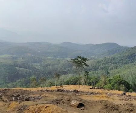
However, it is crucial to address the significant concern raised by a local review: the issue of "rubbish and empty plastic bottles" being left on the hill. While the natural features are appealing, the environmental responsibility of visitors is a critical aspect that directly impacts the overall "highlight" of the area. Efforts from hikers themselves to "bring down own trash and rubbish and dispose them accordingly" are vital to maintain the natural beauty and clean environment of this valuable local asset.
---
As a natural hiking track that appears to be publicly accessible and not managed by a commercial entity, Bukit Liman Hiking Track does not offer "promotions or special offers" in the traditional business sense. There are no entrance fees, membership discounts, or commercial packages. Its inherent "offer" is the free access to a natural environment for hiking and fitness activities.
However, similar to other publicly accessible natural sites, there might be "community initiatives" or "educational campaigns" that indirectly promote responsible use or enhance the experience. While specific current "promotions" for Bukit Liman are not publicly available, based on common practices for natural recreational areas in Perak and Malaysia, these could include:
- Community Clean-Up Drives (Gotong-Royong): Given the feedback about rubbish, local community groups, environmental NGOs, or the Kuala Kangsar Municipal Council (MDKK) might organize volunteer clean-up events to maintain the cleanliness of the track and its surroundings. These are common ways to foster community responsibility.
- Hiking Safety Awareness Campaigns: Information posters or online campaigns about safe hiking practices, proper gear, and emergency contacts might be promoted by local authorities or hiking clubs to ensure a safe experience for visitors.
- "Leave No Trace" Education: Efforts to educate hikers on environmental ethics, such as packing out all trash, staying on marked trails, and respecting wildlife, are crucial for sustaining natural areas.
- Guided Hikes (by local groups): Local hiking clubs or community groups might organize guided hikes for beginners or themed hikes (e.g., birdwatching, nature photography) that showcase the track's features and encourage responsible enjoyment. These are usually non-commercial or involve a small fee for organization.
To find out about any such community-led initiatives or information pertinent to the responsible use of Bukit Liman Hiking Track, locals should check notice boards at the trailhead (if any), follow the social media pages of local hiking groups in Kuala Kangsar or Perak, or refer to the official website/social media of the Kuala Kangsar Municipal Council (MDKK).
---
As a natural hiking track, Bukit Liman Hiking Track does not have a dedicated contact number or a specific office. Its maintenance and oversight would typically fall under the purview of local government authorities responsible for public land and recreational areas, such as the Kuala Kangsar Municipal Council (Majlis Daerah Kuala Kangsar - MDKK) or the District and Land Office.
- Address: Jalan Baling - Gerik, 33020 Kuala Kangsar, Perak, Malaysia
For any inquiries regarding the maintenance of the track, reporting issues (like rubbish dumping), or general information related to local public amenities in Kuala Kangsar, residents would typically contact MDKK. Their general hotline or public feedback channels would be the appropriate avenue. While a direct phone number for the hiking track itself isn't available, the address is clear enough for navigation, especially with its proximity to MRSM SAS.
For those interested in joining group hikes or getting more local insights, searching for Kuala Kangsar or Perak-based hiking community groups on social media platforms (like Facebook or WhatsApp) could provide valuable connections and information from fellow enthusiasts.
---
The Bukit Liman Hiking Track is remarkably suitable for locals in Perak, particularly those in Kuala Kangsar and its surrounding areas, for several compelling reasons. Firstly, its accessibility is a major draw. Situated conveniently along a main road and identifiable by its proximity to MRSM SAS, it offers a readily available outdoor escape for daily exercise or weekend adventures without requiring extensive travel. This ease of access encourages more residents to embrace an active lifestyle and engage with nature regularly.
Secondly, the track perfectly caters to various fitness levels, making it an ideal starting point for beginners to experience the joys of hiking, while still providing a valuable "uphill stamina test" for more seasoned enthusiasts. This inclusivity means that more members of the community can benefit from the physical and mental rewards of hiking, contributing to a healthier and more active local population. The promise of "fresh and clean air at the top" and "nice track & of course view from the top" serves as a powerful motivator, offering both immediate physical refreshment and a rewarding visual spectacle of our beautiful Perak landscape, complete with glimpses of local orchards.
However, the honest feedback about the need for better waste management highlights a critical aspect of its suitability: it is a shared responsibility. The track’s continued appeal and sustainability as a local asset depend significantly on the collective efforts of its users to "bring down own trash and rubbish and dispose them accordingly." This challenge, if addressed collectively by the community and supported by local authorities, can further enhance the track's value and foster a stronger sense of environmental stewardship among locals.
In essence, Bukit Liman Hiking Track is more than just a path up a hill; it is a beloved local resource that offers accessible physical challenge, natural beauty, and a chance for fresh air and stunning views. It perfectly encapsulates the spirit of outdoor adventure that many of us in Perak cherish, making it an indispensable part of our local recreational landscape.
Bukit Liman Hiking Track Photos

Bukit Liman Hiking Track Location
Bukit Liman Hiking Track
Jalan Baling - Gerik, 33020 Kuala Kangsar, Perak, Malaysia
 Bukit Liman Hiking Track
Jalan Baling - Gerik
 Liman Kati Hill Viewpoint
VV4V+3M
 Puncak Bukit Liman Kati (510meter)
Bukit Liman Kati
 Geliong View Hill
Kota Lama Kiri
 Bukit Payung
RW2C+6P
 Kolam Bunian Bukit Payung
QWX8+9J
 pokok kelapa sawit
33010 Padang Rengas
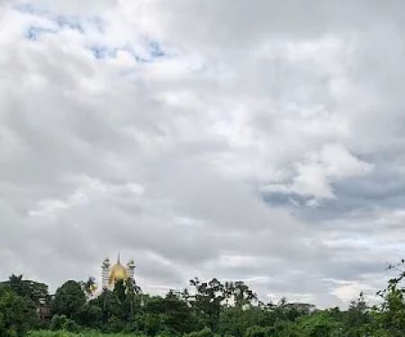
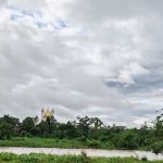 View of Istana Iskandariah and Masjid Ubudiah
33040 Kuala Kangsar
 Rumah konsi
Perak
 Berekeh
Perak
 Water fall
QQMP+F6
 Batu Putih Hill - Trail
Jalan Kampung Pintu Padang
 Bukit Batu Putih
Kampung Pintu Padang
Bukit Liman Hiking Track Reviews
Good place to test your uphill hiking stamina. There are 2 steep sections to reach the top. Fresh and clean air at the top. However, we need to be more civilized and bring down own trash and rubbish and dispose them accordingly.. The empty plastic bottles will remain on the hill for hundreds of years.
Nov 27, 2021 · Redzwan Abdul Rashidnice track & of course view from the top. In front of mrsm sas and we can see lots of orchard during the hiking. Beginners can have a good start here. Good luck babe!
Oct 04, 2022 · asmizan majidQuite challenging. Follow your own pace
Feb 25, 2025 · Sharizal SapingiSuitable for young children. A lot of mosquitoes, pls get your insect repellent ready. Pls give way to the rubber tappers who ride their motorbike up and down.
Jan 02, 2023 · BKcertain part of path, it has incline of 20 degree and above, along the photo, it reach the first beautiful scenery of liman village ( right) and MRSM ( left )
Feb 01, 2022 · Official Game
More Adventure
 Liman Kati Hill Viewpoint4.0 (5 reviews)
VV4V+3M, 33020 Kuala Kangsar, Perak, Malaysia
 Puncak Bukit Liman Kati (510meter)4.0 (7 reviews)
Bukit Liman Kati, 33000 Kuala Kangsar, Perak, Malaysia
 Geliong View Hill5.0 (1 reviews)
Kota Lama Kiri, 33600 Kuala Kangsar, Perak, Malaysia
 Bukit Payung5.0 (1 reviews)
RW2C+6P, 33000 Kuala Kangsar, Perak, Malaysia
 Kolam Bunian Bukit Payung0.0 (0 reviews)
QWX8+9J, Kuala Kangsar, Perak, Malaysia
 pokok kelapa sawit5.0 (1 reviews)
33010 Padang Rengas, Perak, Malaysia
 View of Istana Iskandariah and Masjid Ubudiah5.0 (1 reviews)
33040 Kuala Kangsar, Perak, Malaysia
 Rumah konsi0.0 (0 reviews)
Perak, Malaysia
 Berekeh0.0 (0 reviews)
Perak, Malaysia
 Water fall4.0 (3 reviews)
QQMP+F6, 34850 Changkat Jering, Perak, Malaysia
 Batu Putih Hill - Trail4.0 (297 reviews)
Jalan Kampung Pintu Padang, Kampung Pintu Padang, 31600 Gopeng, Perak, Malaysia
 Bukit Batu Putih0.0 (0 reviews)
Kampung Pintu Padang, 31600 Gopeng, Perak, Malaysia
Categories
Popular
 Dewan Felda Wilayah Raja Alias4.0 (34 reviews)
 Shahid suresh2.0 (1 reviews)
 M.R.M. hotel0.0 (0 reviews)
 ZULTHERAPY SIJANGKANG - KLANG RAWATAN ALTERNATIF SAKIT BADAN DAN TULANG BELAKANG4.0 (21 reviews)
 Izzul Islam Burger3.0 (8 reviews)
 Naura Homestay Selangor Kuala Lumpur4.0 (25 reviews)
Must-Read Blog Posts
Most Searched
Trending Blog Posts
 Exploring the Architectural Beauty of Mosques in Malaysia: A Journey Through Islamic Architecture
 Exploring the Unique Designs of Mosques in Malaysia: A Journey Through Islamic Architecture
 How to Get to the Famous Mosques in Kuala Lumpur by Public Transport: A Complete Travel Guide
 Visiting Malaysia’s Most Famous Mosques During Eid: A Unique Cultural Experience
 Top Mosques to Visit During Ramadan in Malaysia: A Traveler's Guide
 Discover the History of Masjid Titiwangsa in Kuala Lumpur: A Cultural and Architectural Gem