

Starting Point Gunung Nuang via Janda Baik Introduce
For us locals in Pahang, especially those with a passion for serious trekking and mountain adventures, Gunung Nuang stands as a formidable and highly respected peak. While it's often associated with Selangor, a significant and challenging route to its summit begins right here in Pahang, via the tranquil and scenic Janda Baik area. This isn't a casual stroll; it's an arduous journey that demands preparation and determination, but the rewards are immense – a true immersion in the rich rainforest and the ultimate satisfaction of conquering one of Malaysia's significant mountains. From our perspective as Pahang residents, knowing about this starting point means having direct access to an elite hiking experience right in our own state, offering a deep connection with our natural heritage.
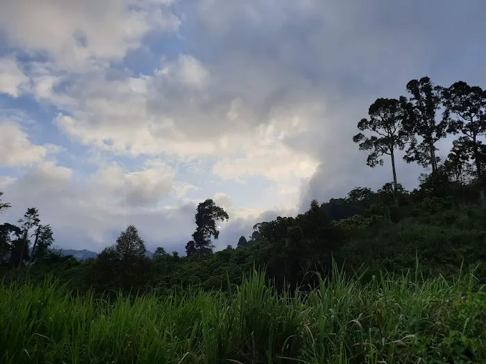
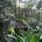
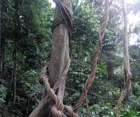
The "Starting Point Gunung Nuang via Janda Baik" refers to the specific trailhead and initial section of the hiking route that ascends Gunung Nuang from the Pahang side. Gunung Nuang, standing at approximately 1,493 meters (4,898 feet), is the highest point in Selangor and a popular hiking destination for experienced trekkers. The Janda Baik route is known for being a longer and often more challenging alternative to the more commonly used Pangsun route from Selangor. It takes hikers through dense rainforest, over streams, and across varied terrain, presenting a true test of endurance and navigational skills.
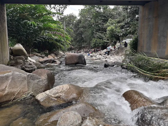
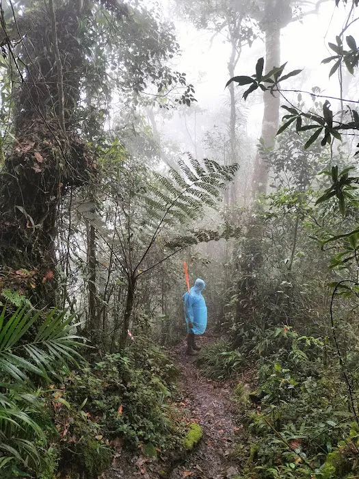
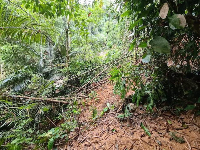
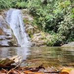
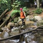
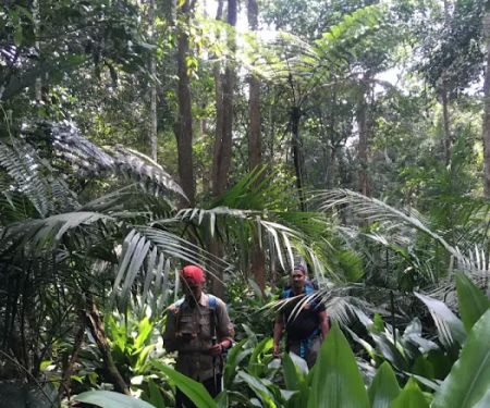
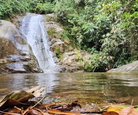
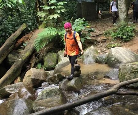
Reviews from real customers emphasize the demanding nature of this hike: it's typically a "daypack hike" requiring at least 1.5 liters of water, with suggestions to bring a small gas cooker to heat water taken from waterfalls along the way. This indicates the presence of natural water sources, though purification is always advised. Hikers should be prepared for a "long and arduous uphill" journey, with the descent being equally demanding. The trail can be muddy, even when it hasn't rained, highlighting the typical rainforest conditions. The summit area is described as "quite chill," necessitating a light windbreaker or emergency blanket, especially after a strenuous climb. This overview confirms that the Janda Baik route is for serious hikers who are well-prepared for a full-day or potentially multi-day expedition into the wilderness. It offers a profound sense of adventure and a deep connection with the natural environment of our beautiful state of Pahang.
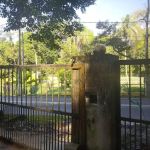
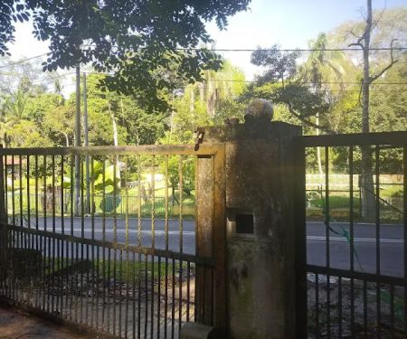
The starting point for Gunung Nuang via Janda Baik is identified by its coordinates: 3.303979, 101.887121, Pahang, Malaysia. These coordinates pinpoint a specific location within the Janda Baik area of Bentong district. Janda Baik itself is a popular highland retreat in Pahang, known for its cool climate, serene ambiance, and lush greenery. For us driving from various parts of Pahang or even from Kuala Lumpur, Janda Baik is conveniently accessible via the Karak-Kuala Lumpur Expressway (E8) or through scenic local roads leading from Bentong or Genting Highlands. Once in Janda Baik, following navigation to the specific coordinates will lead you to the trailhead, which is typically well-marked or known among the local hiking community. Parking is usually available at or near the trailhead, though it might be informal, so arriving early is advisable, especially on weekends.
Public transportation directly to the precise trailhead for Gunung Nuang via Janda Baik is generally not available due to its location within a less developed forest fringe. While there might be bus services to Janda Baik town from Bentong, reaching the specific starting point would almost certainly require a taxi, e-hailing service (like Grab, though availability might be limited in more remote parts of Janda Baik), or, most practically, private transport. Therefore, carpooling with fellow hikers or having your own vehicle is highly recommended for convenience and flexibility when planning this demanding hike. The journey to the trailhead itself is part of the experience, passing through the charming landscapes of Janda Baik, setting the tone for the adventure that lies ahead in the pristine forests of Pahang.
As a natural hiking area and the starting point for a challenging mountain ascent, the "Starting Point Gunung Nuang via Janda Baik" does not offer commercial "services" in the conventional sense, such as shops or staffed facilities. Its primary function is to provide access to the trail and the natural environment. The "services" provided are inherent to the hiking experience and the natural setting:
- Trailhead Access: The starting point provides the entry to the marked (or sometimes less clearly marked) trail leading to Gunung Nuang's summit.
- Natural Water Sources (potential): As noted in reviews, there are likely waterfalls or streams along the trail from which water can be collected (though purification is essential for safety).
- Signage/Markers (likely basic): Basic trail markers indicating direction and possibly distance, maintained by local authorities or hiking communities, should be present at the starting point and along the trail.
- Parking Area: Dedicated or informal parking space near the trailhead for hikers' vehicles.
- Permit Checking (potential): Depending on current regulations, there might be a small ranger post or designated area at the starting point where permits are checked or issued, and entrance fees collected.
- Natural Environment: The primary offering is access to a pristine rainforest ecosystem for immersive hiking, nature appreciation, and wildlife observation.
Hikers must be entirely self-sufficient, carrying all necessary provisions, safety gear, and being prepared for any emergencies, as formal services along the trail are non-existent.
The hike to Gunung Nuang via Janda Baik, starting from this point, offers several significant features and highlights for serious trekkers:
- Challenging Ascent: Known as one of the toughest day hikes in Peninsular Malaysia, providing an arduous but highly rewarding physical and mental challenge.
- Pristine Rainforest Immersion: The trail winds through dense, biodiverse rainforest, offering a deep connection with nature and opportunities to observe various flora and fauna.
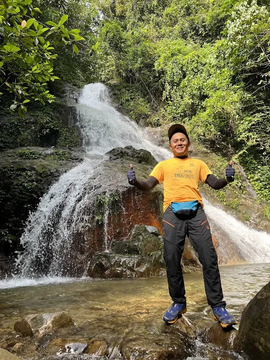
- Water Features: The presence of waterfalls and streams along the route provides scenic beauty and potential natural water sources for refilling (with purification).
- Remote Wilderness Experience: This route offers a more secluded and wilder trekking experience compared to more frequented trails, appealing to adventurers seeking solitude.
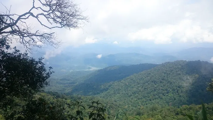
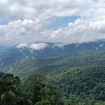
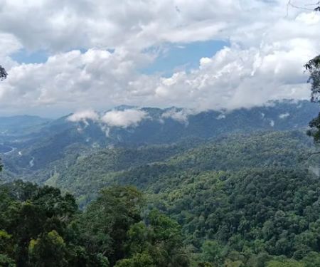
- Summit Views: Reaching the summit of Gunung Nuang (though a long journey from this starting point) offers panoramic views over Selangor and parts of Pahang, a truly breathtaking reward.
- Trail Conditions: Expect muddy and uneven terrain, especially during wet seasons, which adds to the adventure and requires proper hiking footwear and gear.
- Ideal for Training: A popular route for experienced hikers preparing for more demanding multi-day expeditions or mountain climbs due to its length and difficulty.
As a natural hiking area and trailhead for a challenging mountain ascent, the "Starting Point Gunung Nuang via Janda Baik" does not offer commercial promotions or special offers in the typical sense. Access to the trail generally requires a small entrance fee and potentially a permit. Any "promotions" would be related to regulations, community-led initiatives, or guided tours:
- Entrance Fees: Expect a nominal fee (e.g., RM1-RM5 per person) collected by the Forestry Department or appointed caretakers at the trailhead for entry into the forest reserve.
- Permit Requirements: It is highly advisable, and often mandatory for Gunung Nuang, to obtain a hiking permit from the Pahang State Forestry Department (Jabatan Perhutanan Negeri Pahang) or the District Forest Office beforehand. There might be an application fee associated with this.
- Guided Tours: Local hiking guides or adventure companies might offer organized treks to Gunung Nuang via Janda Baik, which bundle guiding services, transportation, and sometimes meals into a package. These are "promotions" for their services.
- Environmental Awareness Campaigns: Occasionally, local environmental groups might organize free clean-up drives or awareness talks at the trailhead.
It is crucial to verify the latest permit requirements, fees, and trail conditions with the Pahang State Forestry Department before planning your hike to Gunung Nuang via Janda Baik.
For information regarding the Starting Point Gunung Nuang via Janda Baik, here are the coordinates and general location:
Address: 3.303979, 101.887121, Pahang, Malaysia (These are GPS coordinates for the trailhead)
As this is a geographical point and trailhead, there isn't a direct phone number for the "Starting Point Gunung Nuang via Janda Baik." For official inquiries related to hiking permits, forest reserve regulations, or safety guidelines for Gunung Nuang, you should contact the Pahang State Forestry Department (Jabatan Perhutanan Negeri Pahang) or the District Forest Office responsible for the Bentong/Janda Baik area. Their contact details are usually available on the official Pahang State Government or Forestry Department websites. For more specific local insights or to find hiking groups, engaging with online communities for hikers in Pahang or Malaysia can be very beneficial.
For us locals in Pahang, the Starting Point Gunung Nuang via Janda Baik offers an unparalleled opportunity for a truly immersive and challenging hiking experience right within our state. It's not for the faint of heart, but for those seeking a rigorous test of endurance and a profound connection with nature, it delivers immensely. This route allows us to explore the wilder, less trodden paths of Gunung Nuang, providing a sense of accomplishment that few other local hikes can match. It’s an ideal training ground for more ambitious climbs and a perfect way to escape the urban sprawl, pushing our limits amidst the pristine beauty of Pahang's rainforests. For serious hikers among us, this starting point represents the beginning of an unforgettable adventure and a cherished part of our state’s natural heritage.
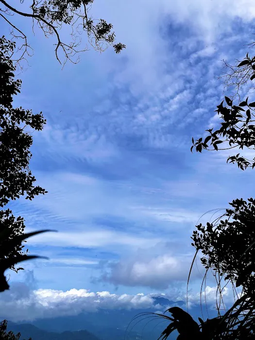
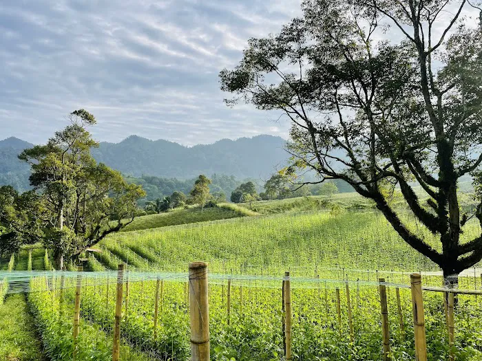
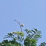
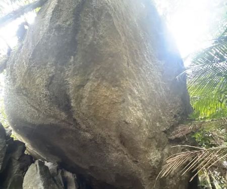
Starting Point Gunung Nuang via Janda Baik Photos


Starting Point Gunung Nuang via Janda Baik Location
Starting Point Gunung Nuang via Janda Baik
3.303979,101.887121, Pahang, Malaysia
 Starting Point Gunung Nuang via Janda Baik
3.303979
 Bukit Repin Trailhead
Unnamed Road
 My Farm
Kampung Janda Baik
 bukit Galang Bendul
28750 Bentong
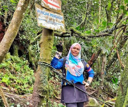
 Puncak Pengasih
Unnamed Road
 Bukit Janda Baik
8VXG+MP
 Kem Pacat
Unnamed Road
 State Boundary of Selangor-N.S-Pahang
Kenaboi
 Birding Place
campong
 Lata Tampit
Kampung Janda Baik
 Kem Lolo
43100 Hulu Langat
 daddy's farm
Setapak
 Taman melawati
Jln Tiara Kemensah 3
Starting Point Gunung Nuang via Janda Baik Reviews
Daypack hike. Bring at least 1.5 liter of water. Otherwise you can bring small gas cooker to heat the water taken from water fall. During raining season, its better to wear good hiking sandal. Even not raining, the trail is a bit muddy.The top is quite chill, bring at least a light windbreaker or emergency blanket. Be prepared for long and arduous uphill. Same thing going down.
Oct 16, 2023 · K NDaypack hike. Bring at least 1.5 liter of water. Otherwise you can bring small gas cooker to heat the water taken from water fall. During raining season, its better to wear good hiking sandal. Even not raining, the trail is a bit muddy.The top is quite chill, bring at least a light windbreaker or emergency blanket. Be prepared for long and arduous uphill. Same thing going down.
Oct 16, 2023 · K NWhole trail was tough. All the way to uphill from starting point. From 551m, all the way up to 1393m. Peak view was not good. I thought there will be 360degree view but nothing. You have to cross a small stream. Near by stream (on right side) there will be nice and cool waterfall. While coming back, I took a dip in water and I totally refreshed. Water was so cold.
Jun 23, 2019 · Midhun DileepWhole trail was tough. All the way to uphill from starting point. From 551m, all the way up to 1393m. Peak view was not good. I thought there will be 360degree view but nothing. You have to cross a small stream. Near by stream (on right side) there will be nice and cool waterfall. While coming back, I took a dip in water and I totally refreshed. Water was so cold.
Jun 23, 2019 · Midhun DileepGot private land parking lot near trailhead. RM10. Trail return distance 15km. Moderate trail not so technical. Got waterfall at bottom. Peak crowded like shopping mall on weekends. Now much of view blocked by trees surrounding. Pastikan ada permit hiking. Pegawai ada berhampiran trailhead. Fine 10k if caught without permit.
Jul 30, 2022 · Agnivickneshwaran R.ChandrasagaranGot private land parking lot near trailhead. RM10. Trail return distance 15km. Moderate trail not so technical. Got waterfall at bottom. Peak crowded like shopping mall on weekends. Now much of view blocked by trees surrounding. Pastikan ada permit hiking. Pegawai ada berhampiran trailhead. Fine 10k if caught without permit.
Jul 30, 2022 · Agnivickneshwaran R.Chandrasagaran1st experience to Gunung Nuang. Did not finished as I got lost hiking the wrong way; but the orang asli is very much helpful to point to the right way. Quite a long stretch of forest cleared for some TNB project. Sad to see this happening to what is supposedly a permanent forest reserve 'Simpanan Hutan Kekal' There's no entrance fee but RM7 to park your car. Yes RM7! But you get to use the toilet/bathing facility free.
Aug 12, 2018 · Bernard Soon1st experience to Gunung Nuang. Did not finished as I got lost hiking the wrong way; but the orang asli is very much helpful to point to the right way. Quite a long stretch of forest cleared for some TNB project. Sad to see this happening to what is supposedly a permanent forest reserve 'Simpanan Hutan Kekal' There's no entrance fee but RM7 to park your car. Yes RM7! But you get to use the toilet/bathing facility free.
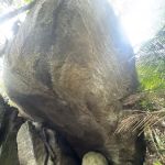
Aug 12, 2018 · Bernard SoonHoray! I'm no. 12 hiker conquered peak of Gunung Nuang yesterday 11 Aug 2018.The trails are strenuos after crossing waterfall Chem'roh that you need to climb up non-stop for 4 to 5 hours.Please bear in mind there are very narrow and dangerous trails at 100m to reach the peak as that deadly trench you barely see the ground below and climb next to big boulders.Be very extra careful as I got to do whatever it takes (kneeling&crawling) to make up above.Follow the "Awas white-red ribbon" alongside the trails.All the best!
Aug 12, 2018 · Juliana JulietteHoray! I'm no. 12 hiker conquered peak of Gunung Nuang yesterday 11 Aug 2018.The trails are strenuos after crossing waterfall Chem'roh that you need to climb up non-stop for 4 to 5 hours.Please bear in mind there are very narrow and dangerous trails at 100m to reach the peak as that deadly trench you barely see the ground below and climb next to big boulders.Be very extra careful as I got to do whatever it takes (kneeling&crawling) to make up above.Follow the "Awas white-red ribbon" alongside the trails.All the best!
Aug 12, 2018 · Juliana Juliette
More Adventure
 Bukit Repin Trailhead4.0 (8 reviews)
Unnamed Road, Bentong, Pahang, Malaysia
 My Farm0.0 (0 reviews)
Kampung Janda Baik, 28750 Bentong, Pahang, Malaysia
 bukit Galang Bendul0.0 (0 reviews)
28750 Bentong, Pahang, Malaysia
 Puncak Pengasih4.0 (38 reviews)
Unnamed Road,, 43100 Hulu Langat, Selangor, Malaysia
 Bukit Janda Baik0.0 (0 reviews)
8VXG+MP, 28750 Bentong, Pahang, Malaysia
 Kem Pacat4.0 (44 reviews)
Unnamed Road, 43100 Hulu Langat, Selangor, Malaysia
 State Boundary of Selangor-N.S-Pahang5.0 (1 reviews)
Kenaboi, Negeri Sembilan, Malaysia
 Birding Place1.0 (1 reviews)
campong, Jalan Sumsum Hilir, Kampung Janda Baik, 28750 Bentong, Pahang, Malaysia
 Lata Tampit3.0 (5 reviews)
Kampung Janda Baik, 28750 Bentong, Pahang, Malaysia
 Kem Lolo4.0 (15 reviews)
43100 Hulu Langat, Selangor, Malaysia
 daddy's farm5.0 (2 reviews)
Setapak, 53100, Selangor, Malaysia
 Taman melawati5.0 (1 reviews)
Jln Tiara Kemensah 3, 68000 Ampang, Selangor, Malaysia
Categories
Popular
 Genting Sunset View4.0 (6 reviews)
 My One Shop2.0 (22 reviews)
 Zul S Homestay2.0 (3 reviews)
 HOMESTAY IBU TAU4.0 (5 reviews)
 910 Homestay5.0 (1 reviews)
 Petico.my Pet Shop Sunway Mentari4.0 (285 reviews)
Must-Read Blog Posts
Most Searched
Trending Blog Posts
 Exploring the Architectural Beauty of Mosques in Malaysia: A Journey Through Islamic Architecture
 Exploring the Unique Designs of Mosques in Malaysia: A Journey Through Islamic Architecture
 How to Get to the Famous Mosques in Kuala Lumpur by Public Transport: A Complete Travel Guide
 Visiting Malaysia’s Most Famous Mosques During Eid: A Unique Cultural Experience
 Top Mosques to Visit During Ramadan in Malaysia: A Traveler's Guide
 Discover the History of Masjid Titiwangsa in Kuala Lumpur: A Cultural and Architectural Gem