

Gunung Kutu Introduce
Selangor, a vibrant state in Malaysia, is renowned not just for its bustling urban centers but also for its stunning natural landscapes, offering a perfect escape for those seeking adventure and tranquility. Among its many natural gems, Gunung Kutu stands out as a highly sought-after destination for hikers. Despite its Malay name "Gunung" (mountain), it is technically a "Bukit" (hill) at 1,053 meters, but don't let that deceive you – the climb offers a truly mountainous experience with rewarding views that are well worth the effort.
For locals in Selangor looking to reconnect with nature, challenge themselves physically, or simply enjoy a day out in the fresh air, Gunung Kutu provides an ideal setting. This comprehensive guide aims to provide you with all the essential information about this captivating hiking area, ensuring you are well-prepared for an unforgettable experience.
Gunung Kutu, often referred to as Bukit Kutu, carries a rich history. It was once a colonial hill station known as "Treacher's Hill" in the late 19th and early 20th centuries, boasting bungalows with amenities like telephones and even a tennis court. However, after being bombed during World War II and eventually abandoned, nature reclaimed its territory, leaving behind intriguing ruins that add a unique historical dimension to your hike. Today, it’s a popular weekend spot, attracting hikers from across Selangor and beyond who are eager to explore its challenging trails and discover its hidden past.
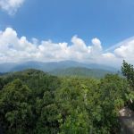
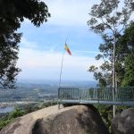
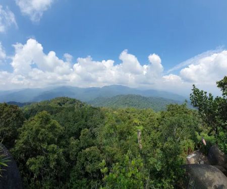
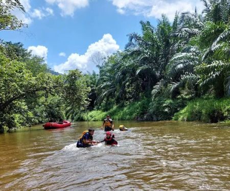
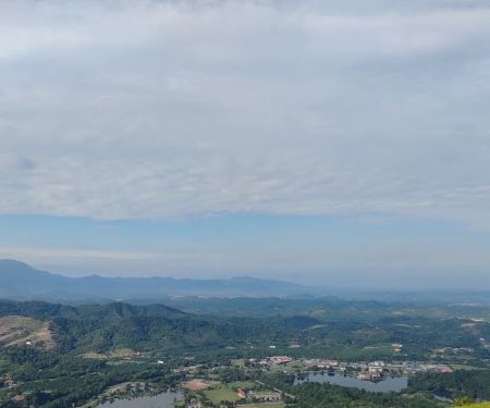
The journey to the summit is an adventure in itself, typically taking between 3 to 4 hours for the ascent, depending on your pace and fitness level. The trail winds through dense jungle, offering a diverse array of flora and fauna. Hikers will encounter several river crossings, some with suspended bridges and others requiring a careful wade through the water. The path can be challenging, with steep sections and natural obstacles like fallen bamboos, adding to the thrill of the climb. Upon reaching the peak, you are rewarded with a magnificent 360-degree panoramic view of the surrounding Titiwangsa mountain range and the serene Kuala Kubu Bharu Dam, a truly breathtaking sight that makes every step worthwhile.
Gunung Kutu is more than just a hike; it’s an immersive experience into Selangor’s natural heritage and a glimpse into its colonial past. Whether you are a seasoned trekker or a beginner looking for a rewarding outdoor activity, Gunung Kutu offers an adventure that caters to varying levels of hiking experience, promising an enriching and memorable outing for everyone.
Location and Accessibility
Gunung Kutu is conveniently located in Kuala Kubu Bharu, Selangor, making it an accessible retreat for many living in the Klang Valley. The address for the starting point of the hike is approximately GPV8+5X, 44000 Kuala Kubu Bharu, Selangor, Malaysia. It is situated along the trunk road leading to Fraser's Hill, just outside the town of Kuala Kubu Bharu (KKB).
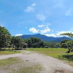
For those driving, the trailhead can be reached by exiting the highway at Rawang and following Route 1 north, then turning right onto Route 55 towards Kuala Kubu Bharu. After passing the Sungai Selangor Dam, look for a sign leading to Kampung Pertak and turn right. Continue along this small tarmac road until you reach the trailhead carpark. Ample parking space is usually available at the trailhead near the Pertak river, which also serves as a popular picnic spot for many visitors.
Public transportation is also an option for reaching the vicinity of Gunung Kutu. You can take the KTM Komuter train to Kuala Kubu Bharu station. From there, the trailhead is approximately 11 kilometers away, and you would need to arrange for local transportation, such as a taxi or e-hailing service, to get to the starting point in Kampung Pertak. While this adds an extra step to your journey, it is a feasible option for those who prefer not to drive.
The proximity of Gunung Kutu to Kuala Kubu Bharu town is an added advantage. KKB offers basic amenities, including eateries and small shops where you can grab a meal or purchase last-minute supplies before or after your hike. This accessibility makes Gunung Kutu a popular choice for day trips, allowing locals to enjoy a fulfilling outdoor adventure without extensive travel.
Services Offered
While Gunung Kutu itself is a natural hiking area and does not offer commercial "services" in the traditional sense, several essential elements and considerations are part of the hiking experience:
- Hiking Trails: The primary service is the well-defined, albeit challenging, hiking trail that leads to the summit. It is generally well-trodden, making navigation relatively straightforward, though some sections may require careful attention.
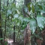
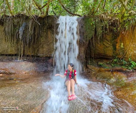
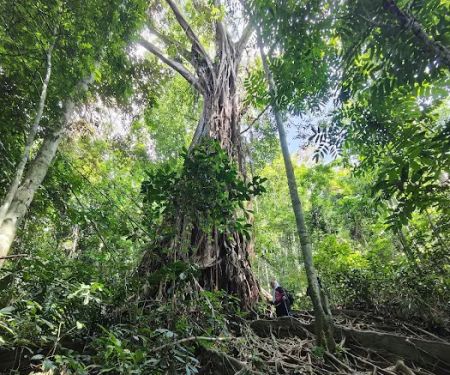
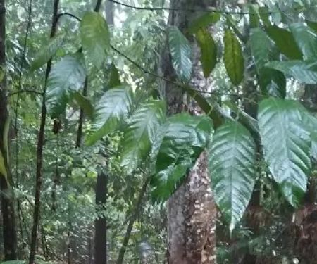
- Natural Environment: Hikers can enjoy the pristine natural environment, including lush rainforests, clear rivers, and diverse flora and fauna. It's a place for nature appreciation and wildlife spotting.
- Historical Exploration: The presence of colonial-era ruins, such as an old chimney, fireplace, and well near the summit, offers a unique historical exploration aspect to the hike.
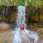
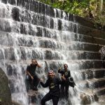
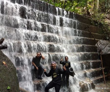
- River Crossings: The trail features several river crossings, adding an element of adventure. Some have suspended bridges, while others require wading, offering refreshing opportunities to cool down.
- Panoramic Views: The main reward and "service" at the summit are the breathtaking 360-degree panoramic views of the Titiwangsa mountain range and the Kuala Kubu Bharu Dam.
- Permit and Guide Services: For hiking in Selangor's permanent forest reserves, permits are generally required. While many experienced hikers navigate Gunung Kutu independently, it is advisable for those less familiar with the trail or hiking in groups to consider engaging a local mountain guide. Contacting local associations like the Hulu Selangor Malim Association or the Selangor Forestry Mountain Guide Association (contact numbers like 019-9194471 or 018-9741651 have been mentioned for guide services) can facilitate this. These guides provide essential safety and navigation support, ensuring a smoother and safer experience.
- Basic Facilities at Trailhead: While not elaborate, there are often basic parking areas and sometimes small vendors near the Kampung Pertak trailhead, where hikers can park their vehicles and potentially purchase light refreshments before starting their ascent.
Features / Highlights
Gunung Kutu is celebrated for a variety of features that make it a compelling hiking destination:
- Challenging Yet Rewarding Trail: The hike is categorized as moderate to challenging, suitable for individuals with a reasonable level of fitness. The approximately 6km one-way trail involves a significant elevation gain of around 800 meters from the trailhead to the summit. The initial sections, particularly checkpoints C1 to C4, are known for their steepness, providing a good workout.
- Historical Ruins: A distinctive feature of Gunung Kutu is the remnants of the old British colonial hill station. Near the summit, hikers can discover the ruins of bungalows, including a prominent chimney, a fireplace, and an old well. These historical artifacts add a layer of intrigue and a sense of stepping back in time amidst the lush jungle.
- Multiple River Crossings: The trail requires crossing three rivers. The first features a suspended bridge, the second has a partially submerged, broken bridge (requiring caution), and the third necessitates wading through the water. These crossings provide unique scenic spots and opportunities for a refreshing break.
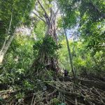
- Diverse Ecosystem: The trail meanders through a rich tropical rainforest, offering opportunities to observe various flora and fauna. Hikers might spot different bird species, insects, and unique plant life, enhancing the natural experience.
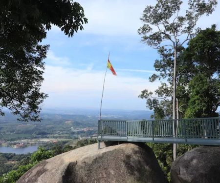
- The Summit Boulder and Ladders: The very top of Gunung Kutu features a large boulder that offers the ultimate panoramic view. To reach this vantage point, hikers need to climb four flights of ladders, adding an exciting and memorable element to the final ascent.
- Stunning Panoramic Views: From the summit, hikers are treated to expansive, breathtaking views of the Kuala Kubu Bharu Dam and the majestic Titiwangsa mountain range. On clear days, the scenery is absolutely spectacular, making the strenuous climb entirely worthwhile. It's often described as a 360-degree vista of clouds, valleys, and mountains.
- Distinctive Chimney Structure: A notable landmark near the summit is the old chimney, a solitary standing structure that marks the site of the former colonial bungalows, serving as a unique photo opportunity.
Promotions or Special Offers
As Gunung Kutu is a natural attraction managed under the Selangor Forestry Department, there aren't typically "promotions" in the commercial sense for the hiking area itself. Access usually requires a permit from the Forestry Department, and any associated fees are standard. However, hikers can sometimes find special offers related to their hiking experience through external providers or product retailers:
- Hiking Tour Packages: Some travel agencies or outdoor activity organizers may offer bundled packages that include transportation, guide services, and permits for Gunung Kutu. For instance, some tour operators might offer packages from Singapore or other parts of Malaysia that cover logistics for a Gunung Kutu hike. These often vary seasonally or based on demand.
- Outdoor Gear Promotions: Retailers specializing in hiking and outdoor equipment, such as PTT Outdoor, occasionally run promotions on gear that is essential for a hike like Gunung Kutu. For example, some might offer "Bukit Kutu Hiking Sets" that include hiking sticks, headlamps, and rain ponchos, sometimes with complimentary items like a first aid kit. Keep an eye out for discounts on hydration systems, appropriate footwear, and rain protection, which are crucial for a comfortable and safe hike.
- Accommodation Deals: If you plan to stay overnight in Kuala Kubu Bharu before or after your hike, local hotels or guesthouses might have their own promotions or packages for visitors interested in outdoor activities. Websites like Expedia may list hotel deals near Kuala Kubu Bharu, which could indirectly benefit hikers visiting Gunung Kutu.
- Group Discounts on Guide Services: While not a formal promotion, engaging a licensed mountain guide as a group might result in a more cost-effective arrangement per person compared to hiring a guide individually.
It is always recommended to check directly with outdoor gear retailers or tour operators for their latest offers, especially if you are planning to purchase new equipment or join an organized group for your Gunung Kutu adventure. For permits, always refer to the official channels of the Selangor Forestry Department.
Contact Information
Since Gunung Kutu is a natural forest reserve and not a commercial entity with a direct customer service line, there isn't a single "contact number" for the hiking area itself. However, for essential information regarding permits and guides, which are crucial for a responsible hike, here are the relevant details:
Address:
- Gunung Kutu (Trailhead): GPV8+5X, 44000 Kuala Kubu Bharu, Selangor, Malaysia
- This is the approximate GPS coordinate for the main trailhead near Kampung Pertak.
For Permit and Guide Information:
- Hulu Selangor Malim Association: +6019-9194471
- Selangor Forestry Mountain Guide Association: +6018-9741651
- These associations can assist with inquiries about obtaining the necessary permits to hike in the forest reserve and can help arrange for licensed mountain guides, which are highly recommended for safety and navigation, especially for those unfamiliar with the terrain or hiking in larger groups.
It is always advisable to contact these organizations in advance of your planned hike to confirm permit requirements, guide availability, and any updated regulations or safety advisories for Gunung Kutu. While there isn't a direct public phone number for the site, these contacts serve as crucial resources for hikers.
Conclusion: Why Gunung Kutu is Suitable for Locals
For residents of Selangor, Gunung Kutu stands out as an exceptional hiking destination, offering a perfect blend of adventure, natural beauty, and historical intrigue right in their backyard. Its accessibility from various parts of Selangor, particularly the Klang Valley, makes it an ideal spot for a day trip or a weekend escape without the need for extensive travel.
Firstly, Gunung Kutu provides a fantastic opportunity for physical activity and mental rejuvenation. The moderate to challenging trails offer a rewarding workout, pushing limits while immersing hikers in the serene sounds and sights of a lush tropical rainforest. After navigating river crossings and steep ascents, reaching the summit and being greeted by the breathtaking panoramic views of the Titiwangsa mountain range and the Kuala Kubu Bharu Dam is an unparalleled feeling of accomplishment and connection with nature. This natural escape is a welcome respite from the hustle and bustle of city life, offering a chance to breathe fresh air and clear one's mind.
Secondly, the historical significance of Gunung Kutu adds a unique layer to the hiking experience. Discovering the abandoned colonial-era ruins—the chimney, fireplace, and well—offers a fascinating glimpse into Malaysia's past. This blend of natural beauty and historical exploration makes the hike more than just a physical challenge; it becomes a journey through time, appealing to those with an interest in local heritage.
Furthermore, Gunung Kutu caters to a range of hikers. While certain sections are challenging, suitable for seasoned trekkers looking for a good workout, the overall experience is manageable for those with a reasonable fitness level. It serves as an excellent training ground for more ambitious climbs or simply a great way to maintain an active lifestyle. The well-marked trails, while natural and rugged, generally make navigation feasible, and the option to engage local guides provides an added layer of safety and insight for all.
The proximity to Kuala Kubu Bharu town means that hikers have convenient access to amenities before and after their adventure, whether it's grabbing a hearty meal, stocking up on supplies, or even finding accommodation for an overnight stay. This logistical ease enhances the overall experience, making it a stress-free outing for local residents.
In essence, Gunung Kutu is more than just a hiking trail; it's a valuable local asset that promotes outdoor recreation, historical awareness, and environmental appreciation. Its combination of natural splendor, challenging yet rewarding terrain, and intriguing history makes it a highly suitable and highly recommended destination for anyone in Selangor looking to embrace the outdoors and create lasting memories.
Gunung Kutu Photos

Gunung Kutu Location
Gunung Kutu
GPV8+5X, 44000 Kuala Kubu Bharu, Selangor, Malaysia
 Gunung Kutu
GPV8+5X
 Bukit Kutu
44000
 Cherandong Waterfall
HM4R+2G
 Lata Medang
HP9Q+GR
 Cherandong Waterfall Trailhead
Jalan Kampung Buluh Telur
 Bukit Kutu & Gunung Rajah Trailhead
44000
 Bukit Batu Pahat Trailhead
Buluh Telor
 Taman Luncur Udara Signage
Unnamed Road
 KL Hiking Meetup Point
Unnamed Road
 Bukit Batu Belah
Bukit Batu Pahat Trail via
 Bukit Batu Pahat (Puncak)
44000 Kuala Kubu Bharu
 Kem Bina Semangat Yayasan Selangor, Kuala Kubu Bharu
Unnamed Road
 Trailhead Bukit Batu Pahat via indian temple
Buluh Telor
Gunung Kutu Reviews
Wow
Dec 30, 2024 · AbDuLlAh AdEb
More Adventure
 Bukit Kutu4.0 (233 reviews)
44000, Selangor, Malaysia
 Cherandong Waterfall4.0 (5 reviews)
HM4R+2G, 44000 Kuala Kubu Bharu, Selangor, Malaysia
 Lata Medang4.0 (18 reviews)
HP9Q+GR, 44000 Kuala Kubu Bharu, Selangor, Malaysia
 Cherandong Waterfall Trailhead4.0 (48 reviews)
Jalan Kampung Buluh Telur, 44000 Kuala Kubu Baru, Selangor, Malaysia
 Bukit Kutu & Gunung Rajah Trailhead4.0 (152 reviews)
44000, Selangor, Malaysia
 Bukit Batu Pahat Trailhead4.0 (4 reviews)
Buluh Telor, 44000 Kuala Kubu Bharu, Selangor, Malaysia
 Taman Luncur Udara Signage4.0 (6 reviews)
Unnamed Road, Kampung Ampang Pechah, 44000 Kuala Kubu Baru, Selangor, Malaysia
 KL Hiking Meetup Point1.0 (1 reviews)
Unnamed Road, Kampung Ampang Pechah, 44000 Kuala Kubu Baru, Selangor, Malaysia
 Bukit Batu Belah4.0 (19 reviews)
Bukit Batu Pahat Trail via, Jalan, 44000 Kuala Kubu Baru, Selangor, Malaysia
 Bukit Batu Pahat (Puncak)4.0 (37 reviews)
44000 Kuala Kubu Bharu, Selangor, Malaysia
 Kem Bina Semangat Yayasan Selangor, Kuala Kubu Bharu4.0 (106 reviews)
Unnamed Road,, 44000 Kuala Kubu Bharu, Selangor, Malaysia
 Trailhead Bukit Batu Pahat via indian temple4.0 (9 reviews)
Buluh Telor, 44000 Kuala Kubu Bharu, Selangor, Malaysia
Categories
Popular
 SHAHDALIA HOMESTAY KUALA KANGSAR5.0 (2 reviews)
 Ayurose Villa Homestay (Swimming Pool & Event Place)3.0 (12 reviews)
 Port memikat serindit power0.0 (0 reviews)
 Pendamar Villa, Taman Kota Pendamar3.0 (73 reviews)
 Homestay murah shah alam @ taman sri aman 13.0 (13 reviews)
 Healy Mac's Irish Bar & Restaurant - Changkat4.0 (1024 reviews)
Must-Read Blog Posts
Most Searched
Trending Blog Posts
 Exploring the Architectural Beauty of Mosques in Malaysia: A Journey Through Islamic Architecture
 Exploring the Unique Designs of Mosques in Malaysia: A Journey Through Islamic Architecture
 How to Get to the Famous Mosques in Kuala Lumpur by Public Transport: A Complete Travel Guide
 Visiting Malaysia’s Most Famous Mosques During Eid: A Unique Cultural Experience
 Top Mosques to Visit During Ramadan in Malaysia: A Traveler's Guide
 Discover the History of Masjid Titiwangsa in Kuala Lumpur: A Cultural and Architectural Gem